
WESCAN GOLDFIELDS COMMENCES UAV MAGNETIC AND LIDAR SURVEYS AT MUNRO LAKE PROJECT
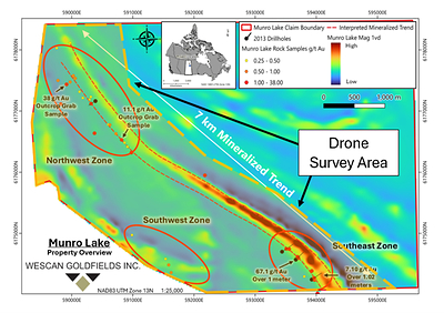
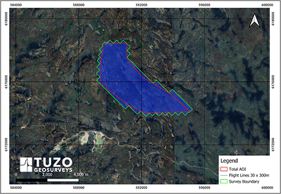
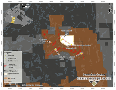
Published on 09/16/2026 at 23:45 | dgap, AD HOC NEWS| Wescan Goldfields Inc.; Wescan Goldfields Inc. / Key word(s): Miscellaneous 16.09.2026 / 23:45 CET/CEST The issuer is solely responsible for the content of this announcement. /NOT FOR DISSEMINATION IN THE UNITED STATES OR FOR DISTRIBUTION TO U.S. WIRE SERVICES/ Highlights: UAV magnetic and LiDAR surveys now underway at Munro Lake to map the faults and contacts that are favourable targets for gold mineralization Approximately 520 line-kilometres on 30-metre flight lines with 300-metre tie lines, covering 11.6 square kilometres along the 7-kilometre mineralized trend Flown by Chase Wood, P.Geo., M.Sc., of TUZO GeoSurveys Corp., whose M.Sc. thesis mapped the adjacent Seabee/Santoy gold complex**. Chase will apply his local expertise by also mapping the orientation of the gold mineralization on surface to guide the 2026 drilling Survey data to be integrated with historical drilling and surface grab samples* to prioritize additional drill-ready targets Munro Lake lies 7 kilometres northeast of SSR Mining's Seabee mine and mill complex, Saskatchewan's only producing gold operation** SASKATOON, SK, Sept. 16, 2026 /PRNewswire/ -- Wescan Goldfields Inc. (TSXV: WGF) (FSE: W17A) ("Wescan" or the "Company") is pleased to announce that high-resolution unmanned aerial vehicle (UAV) magnetic and LiDAR surveys are now underway at its Munro Lake Project in northern Saskatchewan. The surveys are designed to map the faults and contacts that are favourable targets for gold mineralization at the project and to refine drill targets along the 7-kilometre mineralized trend ahead of the Company's 2026 drill campaign. Gold at Munro Lake occurs in quartz veins developed along and adjacent to structural breaks, and the Company considers the intersections, flexures and dilational jogs along those breaks to be the most prospective settings for wider or higher-grade mineralization. High-resolution magnetics resolve these structures through the offset, truncation and alteration of magnetic stratigraphy, while LiDAR-derived terrain modelling images their surface expression as topographic lineaments, breaks in slope and outcrop patterns beneath variable overburden. Mapping that structural framework across the property is the principal objective of the survey. The magnetic survey also carries the potential to detect mineralized structures directly. Gold-bearing quartz veins at Munro Lake commonly contain pyrrhotite, a magnetic iron sulphide, which may produce discrete magnetic responses over individual veins in addition to the broader structural signature resolved by the survey. The magnetic survey is being flown on 30-metre flight lines with 300-metre tie lines oriented northeast–southwest, broadly perpendicular to the interpreted trend of mineralization, for a total of approximately 520 line-kilometres. Coverage totals approximately 11.6 square kilometres (1,160 hectares) in a single contiguous block extending along the 7-kilometre mineralized trend and encompassing the Northwest, Southwest and Southeast zones (Figure 1); the survey area and flight line layout are shown in Figure 2. Drone-based magnetics provide much tighter line spacing and lower flight heights than conventional fixed-wing or helicopter surveys, yielding a level of structural detail those platforms cannot resolve. The surveys are being flown by TUZO GeoSurveys Corp. of Calgary, Alberta, under the direction of Chase Wood, P.Geo., M.Sc., the firm's Chief Executive Officer. Mr. Wood's M.Sc. research was completed on the adjacent Seabee/Santoy gold complex and is titled Structural study of the auriferous Santoy shear zone, northeastern Glennie domain, Saskatchewan (2016). His familiarity with the regional geology and the structural style of the Seabee/Santoy corridor is expected to aid in the rapid interpretation of the Munro Lake data and in translating geophysical anomalies into practical drill targets**. In conjunction with the airborne surveys, Mr. Wood will complete limited structural mapping in the southeast zone, where Wescan's 2013 diamond drilling intersected 67.1 g/t gold over 1.00 metre*** in drill hole EXML-002 and 7.1 g/t gold over 1.02 metres*** in EXML-001 (see Company news release dated June 17, 2013). The mapping will measure the strike and plunge of the gold-bearing quartz veins exposed at surface in this area. Establishing the orientation and plunge of the vein system is expected to inform the siting, azimuth and dip of holes in the Company's upcoming 2026 drill campaign, which is intended to test the extent of the 2013 mineralization down-plunge and along strike. When integrated with historical drill holes, surface grab samples*, and geological mapping, these datasets will allow the Company to refine its structural interpretation, prioritize drill-ready targets along the trend, and more effectively position future drill holes to test down-plunge extensions and structurally dilated zones. This workflow bridges the gap between broad reconnaissance and precise drill planning, helping Wescan lower exploration risk and focus capital on the highest-confidence targets ahead of subsequent drilling phases.
     View original content to download multimedia:https://www.prnewswire.com/de/pressemitteilungen/wescan-goldfields-commences-uav-magnetic-and-lidar-surveys-at-munro-lake-project-302881173.html View original content to download multimedia:https://www.prnewswire.com/de/pressemitteilungen/wescan-goldfields-commences-uav-magnetic-and-lidar-surveys-at-munro-lake-project-302881173.html  16.09.2026 CET/CEST Dissemination of a Corporate News, transmitted by EQS News - a service of EQS Group. The issuer is solely responsible for the content of this announcement. The EQS Distribution Services include Regulatory Announcements, Financial/Corporate News and Press Releases. View original content: EQS News |
en | boerse | 70113634 |


