
Ayeyarwady River curving past the temple plain of Bagan
Published on 09/09/2026 at 06:03 | Editorial responsibility: Rafael Müller, Editor-in-Chief AD HOC NEWS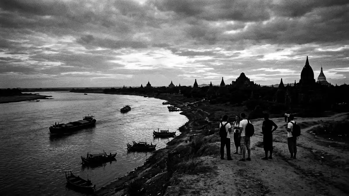
Ayeyarwady River, known in older English texts as the Irrawaddy River, is the principal river of Myanmar and flows past the temple plain of Bagan in a wide, slow curve.principal river of Myanmar Here, in central Myanmar’s dry zone, the waterway and the clustered stupas share the same long horizon, giving Bagan a river frontage that is part working landscape and part archaeological panorama.temple plain of Bagan
Ayeyarwady River and Bagan’s eastern bank
Bagan stands on the eastern bank of Ayeyarwady River in central Myanmar, where the land drops towards the water in terraces and low bluffs that frame the temple plain.eastern bank of Ayeyarwady The archaeological zone stretches along this river margin, with Old Bagan close to the embankment and the newer settlements of Nyaung U and New Bagan extending inland across drier ground.Bagan archaeological zone
From the river, the density of pagodas becomes clear as thousands of brick stupas, temples and monasteries rise from the plain behind the bank, many dating to the eleventh and twelfth centuries when Bagan was a royal centre.eleventh and twelfth centuries Boats moving along the Ayeyarwady pass riverfront shrines such as Bupaya Pagoda, a landmark directly above the water, and give views back towards major temples deeper inland, where spires and tiered roofs stand above tree lines and fields.Bupaya Pagoda above the river
The course of Ayeyarwady River through Myanmar
Ayeyarwady River rises in the far north of Myanmar from the confluence of the N’mai and Mali rivers in Kachin State, carrying water southwards from glaciated mountains into the country’s central plains.confluence of N’mai and Mali From this northern meeting point it flows the length of Myanmar, passing major towns including Mandalay and Bagan before eventually dispersing into a broad delta that reaches the Andaman Sea.from northern confluence to delta
The river’s length is about 2,100 km (1,300 miles), and its drainage basin covers more than 404,000 sq km (156,000 sq mi), taking in much of Myanmar’s agricultural heartland.length and basin of Ayeyarwady Its annual rise during the monsoon months feeds fertile banks and the extensive delta, helping to sustain rice-growing regions that form a central part of the country’s economy, while navigable reaches provide an important inland waterway linking northern and southern Myanmar.
River life and temple landscapes at Bagan
At Bagan the broad channel of Ayeyarwady River runs beside an expanse of pagodas and stupas on slightly raised ground, so the temple plain and river form a continuous landscape of brickwork, sandbars and cultivated plots.bend beside the temple plain River craft range from small wooden boats serving nearby villages to larger vessels travelling between Mandalay, Bagan and points further downstream, and they pass fields, groves and simple landing places on the way.
The temple plain itself holds a dense concentration of Buddhist monuments, with large structures such as Ananda Temple emerging from clusters of smaller brick shrines that stand between tracks, trees and patches of farmland.dense concentration of temples From boats on the Ayeyarwady the view takes in this spread of towers and terraces, showing how religious architecture, river transport and everyday rural life coexist across the Bagan plain.
Visiting Ayeyarwady River: what travellers from Western Europe should know
- Ayeyarwady River runs through central Myanmar and Bagan stands on its eastern bank, reached via domestic connections to Nyaung U and onward local road or river transport.
- The river frontage at Bagan includes embankments, informal landing places and pagoda terraces above the water, with approaches that may involve uneven ground and steps.
- Bagan lies in Myanmar, where the official language is Burmese and the currency is the kyat.
- Entry requirements depend on your nationality; UK travellers can check the FCDO travel advice at gov.uk/foreign-travel-advice, Irish travellers the Department of Foreign Affairs at ireland.ie.
Searching for Ayeyarwady River on social platforms
These links open searches for Ayeyarwady River on each platform.
Frequently asked questions about Ayeyarwady River
Where is Ayeyarwady River in relation to Bagan?
Ayeyarwady River flows through central Myanmar and at Bagan it forms a broad bend beside the temple plain, with the city standing on the eastern bank.
What can visitors expect when they reach the river at Bagan?
Visitors find embankments, pagodas directly above the water and views across a wide river channel, with boats serving local transport and longer journeys along the valley.
What makes the Ayeyarwady River landscape distinctive at Bagan?
The combination of a major inland waterway, a dense spread of Buddhist temples from the eleventh and twelfth centuries and working fields creates a single, layered landscape.


