
Barrancas del Cobre around Creel, a canyon world in northern Mexico
Published on 09/21/2026 at 19:20 | Editorial responsibility: Rafael Müller, Editor-in-Chief AD HOC NEWS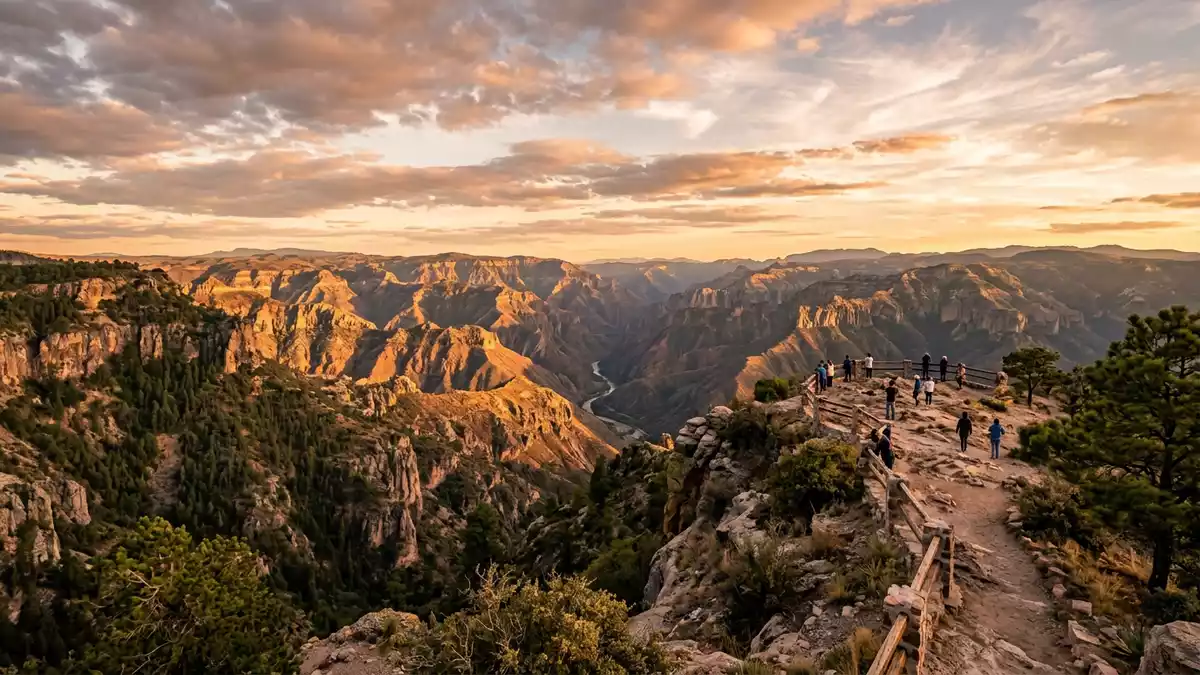
Barrancas del Cobre, known in English as Copper Canyon, is a vast system of canyons cut into the Sierra Madre Occidental in the Mexican state of Chihuahua, with the mountain town of Creel sitting near its high rims.Copper Canyon The canyon country reaches across tens of thousands of square kilometres, and the contrast between high pine-covered plateaus and deep river gorges gives this landscape its character.system of interconnected canyons
Canyon scale and the Sierra Tarahumara setting
Barrancas del Cobre lies in the Sierra Tarahumara, part of the wider Sierra Madre Occidental, where rivers have carved a network of ravines into the high plateau of northern Mexico.Sierra Tarahumara highlands The canyon system covers roughly 60,000 to 65,000 km² (about 23,000 to 25,000 sq mi), a figure that refers to the wider canyon country rather than a single protected area.extent of the canyon system Several named gorges form this landscape, including Urique Canyon, which reaches a depth of around 1,879 m (6,165 ft) and is recognised as the deepest canyon in Mexico.Urique, Mexico's deepest canyon
The altitude difference between canyon floors and rims shapes the scenery. At the lower levels, near 300 m (985 ft) above sea level, river valleys cut through warmer zones with varied vegetation, while the rims rise above 2,300 m (7,545 ft) into pine and oak forests with cooler mountain air.altitude shifts from floor to rim Creel itself stands on the high plateau at about 2,350 m (7,710 ft), making it one of the higher points on the railway route that crosses the region.Creel altitude and railway From viewpoints near Creel and at rim-side areas such as Divisadero, visitors look down into branching gorges that run far into the Sierra, with rock walls, wooded slopes and distant riverbeds forming layered horizons.
Creel as mountain town and gateway
Creel is a compact town recognised as a Pueblo Mágico, a national designation for places with particular cultural and natural significance, and it serves as one of the main gateways to Barrancas del Cobre.Creel, Pueblo Mágico It lies around 247 km south-west of the city of Chihuahua, in the highlands of the Sierra Tarahumara, and forms part of the Barrancas del Cobre tourist region described in national and international tourism sources.Barrancas del Cobre tourist region Streets in Creel are lined with low-rise buildings, and its altitude and surrounding forests give it a mountain character distinct from many other Mexican towns.
Creel stands within territory closely associated with the Rarámuri, also known as Tarahumara, an Indigenous people whose communities live across the canyon region and high plateau.land of the Tarahumara Their villages and scattered dwellings appear along canyon rims, slopes and clearings, and aspects of their culture form part of the everyday landscape around Creel, from language and dress to the use of footpaths that connect settlements with grazing areas and fields. The town has become a named point of contact between the wider Mexican rail and road network and this highland world, with visitors arriving and then continuing towards viewpoints, waterfalls and small communities along the canyon edges.rail gateway at Creel
Rail lines, viewpoints and canyon excursions
Barrancas del Cobre is closely linked with the Ferrocarril Chihuahua al Pacífico, commonly known as El Chepe, a rail line that runs between the inland city of Chihuahua and the Pacific coast near Los Mochis, crossing the canyonlands on its way.Chihuahua al Pacífico Railway The rail journey between Creel and Los Mochis covers about 350 km (220 mi) and passes over numerous bridges and through many tunnels as it descends and climbs along the canyon edges.bridges and tunnels along the line Carriages with larger windows and dome sections allow uninterrupted views of cliffs, slopes and distant ravines, and certain stations near the canyon rims have become fixed stopping points for travellers combining the railway with short walks to viewpoints.
From Creel and other points on the high plateau, day excursions reach rim-side parks and natural sites linked with Barrancas del Cobre. Near Divisadero, for example, an adventure park offers cable-car crossings over a canyon, zip lines along the cliffs and paths that follow the rim, all set against long views into the branching ravines.Barrancas Adventure Park Other routes from Creel lead towards waterfalls and rock formations in the wider Barrancas del Cobre national park area, including cascades such as Basaseachi and Piedra Volada, which appear in descriptions of the region as some of the highest falls in Mexico.cascades within Barrancas del Cobre
Visiting Barrancas del Cobre: what travellers from Western Europe should know
- Barrancas del Cobre lies in northern Mexico in the state of Chihuahua, with Creel acting as a gateway town on the high plateau of the Sierra Tarahumara; the Chihuahua al Pacífico railway, known as El Chepe, connects Creel with the Pacific coast near Los Mochis and the inland city of Chihuahua.
- The terrain around Barrancas del Cobre combines high-altitude plateaus, canyon rims and steep slopes, so walks from Creel and rim-side stations can involve uneven ground, significant gradients and sections of path that follow the edge of ravines.
- Creel is part of the Barrancas del Cobre tourist region, and many excursions link the town with viewpoints, waterfalls and Rarámuri communities scattered across the canyon country, reached by vehicle and on foot.
- The official language is Spanish and the currency is the Mexican peso.
- Entry requirements depend on your nationality; UK travellers can check the FCDO travel advice at gov.uk/foreign-travel-advice, Irish travellers the Department of Foreign Affairs at ireland.ie.
Searching for Barrancas del Cobre on social platforms
These links open searches for Barrancas del Cobre on each platform.Frequently asked questions about Barrancas del Cobre
Where is Barrancas del Cobre and how is it related to Creel?
Barrancas del Cobre is a canyon system in the Sierra Madre Occidental in Chihuahua, northern Mexico, and Creel is a highland town that serves as a gateway to its rims.
What should visitors expect when exploring Barrancas del Cobre?
Visitors encounter high plateaus, deep ravines, pine and oak forests, rail journeys along cliff edges and excursions from Creel to viewpoints, waterfalls and Rarámuri communities.
What makes Barrancas del Cobre distinctive compared with other canyon regions?
The combination of very deep gorges such as Urique, a canyon country larger than many single-park landscapes and the presence of long-established Rarámuri settlements along the rims gives Barrancas del Cobre its distinctive character.


