
Bathsheba and the Atlantic edge of Saint Joseph
Published on 09/18/2026 at 20:25 | Editorial responsibility: Rafael Müller, Editor-in-Chief AD HOC NEWS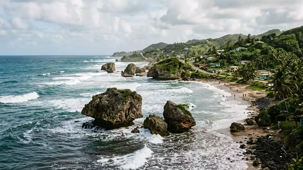
Bathsheba in Saint Joseph on Barbados’s east coast is a fishing village where houses, reef and Atlantic surf meet along a rugged shoreline. Its position on the island’s Atlantic side, within the Scotland District, gives Bathsheba a character very different from the calmer western bays of Barbados, with the village closely tied to the sea and to the waves that break just offshore in the Soup Bowl surf break.
Bathsheba between village, reef and Scotland District hills
Bathsheba lies on the east coast of Barbados in the parish of Saint Joseph, facing directly onto the Atlantic Ocean and backed by the higher ground of the Scotland District to the west.Bathsheba lies on the east coast The settlement is described as the main fishing village in Saint Joseph, with local housing and small streets arranged along and above the shoreline in a loose pattern that follows the contours of the coast.main fishing village in Saint Joseph
The coastline at Bathsheba is marked by dark coral and limestone rock, small sandy sections and offshore reef shelves that break the Atlantic swells. Inland, the land rises towards the Scotland District, a landscape of hills and gullies that forms Barbados’s most rugged terrain and frames Bathsheba from above.Scotland District This setting gives the village a clear separation from the busier, low-lying western resorts, with the Atlantic-facing coast feeling exposed to ocean and wind while the interior climbs away behind it.
Soup Bowl and the Atlantic surf off Bathsheba
Just offshore from Bathsheba lies Soup Bowl, a right-hand reef break regarded as one of the most consistent waves in Barbados, formed where Atlantic swells hit a coral and limestone reef shelf.Soup Bowl right-hand reef break The break sits in the open Atlantic on the island’s eastern side and is described as handling wave faces from several feet to well overhead, with barrels that form over the reef when north-east to south-east swells meet offshore winds.powerful reef break
Soup Bowl has become closely associated with surf culture in Barbados, drawing experienced surfers who paddle out from the shore to the lineup beyond the inshore rocks. The bottom is a mix of coral and limestone reef, and the wave is described as powerful and hollow, with hazards including sea urchins and shallow sections on the inside.coral with limestone reef From the land, the surf can be watched from the grassy bluffs and the roadside above the break, where the contrast between the white water of the Atlantic and the dark reef beneath is part of Bathsheba’s coastal view.
Rock pools, coastal features and neighbouring bays
Along Bathsheba’s shore, Atlantic waves have carved and undercut coral and limestone outcrops, leaving large rock heads standing in the shallows and shallower areas closer to the beach. These formations, together with lower reef shelves, create tide pools sometimes referred to as Bathsheba Pools, where seawater collects among the rocks at lower tide and forms sheltered patches distinct from the breaking surf beyond.Bathsheba Pools
South of Bathsheba, Tent Bay lies within walking distance along the coast road and functions as a working fishing cove with wooden boats and an anchorage tucked among darker coral cliffs.Tent Bay fishing village Together, Bathsheba and its neighbouring bays form a stretch of Atlantic-facing shoreline where fishing activity, surf breaks and rock pools are all part of the same narrow band between hills and sea.
Visiting Bathsheba: what travellers from Western Europe should know
- Bathsheba is on Barbados’s east coast in the parish of Saint Joseph and is reached by road from other parts of the island, including routes that descend from the higher ground of the Scotland District.
- The shoreline around Bathsheba includes uneven rock, reef shelves and sections of sand, with some approaches involving short walks over rough ground or down slopes from the village road.
- Within Saint Joseph the Atlantic-facing bays sit relatively close together, so it is possible to move on foot along parts of the coast road between Bathsheba and neighbouring Tent Bay.
- Barbados’s official language is English and the currency is the Barbadian dollar.
- Entry requirements depend on your nationality; UK travellers can check the FCDO travel advice at gov.uk/foreign-travel-advice, Irish travellers the Department of Foreign Affairs at ireland.ie.
Searching for Bathsheba on social platforms
These links open searches for Bathsheba on each platform.
Frequently asked questions about Bathsheba
Where is Bathsheba and what kind of place is it?
Bathsheba is a fishing village on the Atlantic-facing east coast of Barbados, within the parish of Saint Joseph, backed by the hills of the Scotland District.
What should visitors expect when they reach Bathsheba?
Visitors encounter a narrow band of settlement along a rugged shoreline, with Atlantic surf breaking over reef, large coastal rock formations, tide pools and views inland to higher ground.
What makes Bathsheba distinctive compared with other Barbados coasts?
Bathsheba’s defining features are its open Atlantic exposure, the Soup Bowl reef break just offshore and the way fishing activity, coastal rock pools and surf share the same compact stretch of coast.


