
Bay of Islands and Paihia’s sheltered maze of sea and land
Published on 09/21/2026 at 15:26 | Editorial responsibility: Rafael Müller, Editor-in-Chief AD HOC NEWS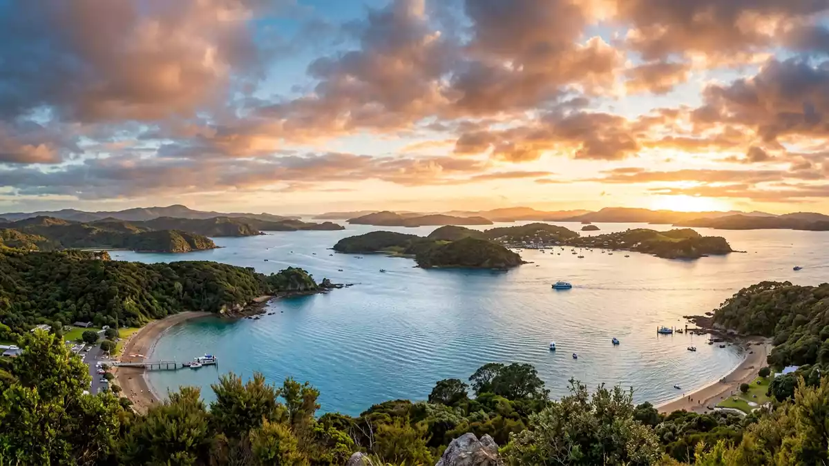
Bay of Islands on the east coast of Northland in New Zealand forms a wide, irregular drowned river system of islands and inlets, with the town of Paihia facing its sheltered waters.The Bay of Islands is located on the North Island and lies north-west of Whang?rei.The bay in Northland The bay sits near historic coastal settlements such as Paihia, Russell, Waitangi and Kerikeri, all arranged around an expanse of water with many arms reaching into the land.Northland places
A drowned landscape of islands and inlets
Bay of Islands is described as a natural bay with an irregular coastline extending for many kilometres, shaped where the Pacific has flooded a network of former river valleys.An expanse of water with long inlets The wider bay stretches between headlands including R?kaumangamanga near Cape Brett and Tokerau, enclosing channels that lead towards the open sea.Outer limits marked by headlands Within this enclosure, the water surface is broken by more than one hundred islands, ranging from low rock outcrops to larger vegetated landforms that rise from the sea.
The bay’s broad entrance narrows into several long arms, such as those reaching inland towards Kerikeri and Te Puna, while other inlets curve around sheltered anchorages used by boats and small craft.Inlets including Kerikeri and Te Puna Some parts of the coastline show signs of past volcanic activity, with eruption outlets and lava flows recorded in the surrounding hills, adding geological variety to the drowned valley system.Volcanic activity and lava flows The combination of enclosed water, complex shoreline and scattered islands creates a maze-like maritime landscape that can be traced on charts and experienced from ferries and cruise vessels.
Paihia and the historic settlements around the bay
Paihia stands on the shore of Bay of Islands as one of the main coastal towns, linked by road to the rest of Northland and by wharf to routes across the bay.Paihia on the Bay of Islands The town covers a compact area between the Waitangi River and the Haumi River, forming a ribbon of development along the beach and low hills above the foreshore.Extent between rivers From the waterfront, ferries and smaller boats cross the bay, linking Paihia with coastal settlements including Russell and with the outer islands scattered across the water.Ferries between Paihia and Russell
The shores of Bay of Islands carry a sequence of historic communities where early European missions and M?ori settlements were established in the nineteenth century.Missions at Kerikeri and Paihia Kerikeri lies inland along one of the bay’s inlets and has grown into the largest town in the area, while Paihia follows as a smaller coastal centre and Russell retains a compact historic core across the water.Kerikeri as the biggest town Nearby Waitangi, on the opposite bank of the Waitangi River from Paihia, is associated with the Treaty House and surrounding grounds, which mark a key site in New Zealand’s political history.Treaty House at Waitangi
Water-based journeys across Bay of Islands
Bay of Islands is widely recognised for boating, sailing and fishing, with sheltered waters that support a broad range of maritime activities.Fishing and sailing destination Passenger ferries move between Paihia and Russell, providing a regular link across the inner bay, while vehicle ferries connect Opua and the opposite shore for road traffic heading towards the historic peninsula.Passenger and vehicle ferries From Paihia’s wharf, cruise vessels and smaller boats depart for routes among the islands, towards Cape Brett and through channels that reach features such as the well-known opening in the rock at the tip of the peninsula.Cruises to Cape Brett
The area gained an early international profile in recreational fishing through the writings of American author Zane Grey in the 1930s, when descriptions of large game fish drew attention to waters off Bay of Islands.Big-game fishing publicised in the 1930s Boats now operate from several harbours and jetties around the bay, giving access to coves, beaches and channels that are separated from the open coast by headlands and islands. For travellers basing themselves in Paihia, links by road to Kerikeri and by ferry to Russell make it practical to explore both shore and water, with each settlement presenting a different vantage point on the same marine landscape.Boutique towns around the bay
Visiting Bay of Islands: what travellers from Western Europe should know
- Bay of Islands lies on the east coast of the North Island in New Zealand’s Northland region, with Paihia linked to the national highway network and ferries crossing the bay to Russell.
- The terrain around Paihia combines low hills and a coastal strip; walking routes between town and viewpoints can include gradients and sections on formed tracks or beach.
- The bay sits north-west of Whang?rei, with Kerikeri inland along one of its inlets and Waitangi across the river from Paihia, so several named settlements are within short travelling distances of each other.
- The official language is English and the currency is the New Zealand dollar.
- Entry requirements depend on your nationality; UK travellers can check the FCDO travel advice at gov.uk/foreign-travel-advice, Irish travellers the Department of Foreign Affairs at ireland.ie.
Searching for Bay of Islands on social platforms
These links open searches for Bay of Islands on each platform.Frequently asked questions about Bay of Islands
Where is Bay of Islands in relation to Paihia?
Bay of Islands surrounds the coastal town of Paihia on the east coast of Northland, with the town facing directly onto the sheltered inner waters of the bay.
What can travellers expect when visiting Bay of Islands from Paihia?
Travellers basing themselves in Paihia encounter a compact seaside town with a wharf, beaches and ready access to cruises, ferries and coastal walks that explore the bay’s islands and inlets.
What makes Bay of Islands distinctive among New Zealand’s coastal regions?
The combination of an irregular drowned valley coastline, more than one hundred islands, historic settlements such as Kerikeri, Russell, Paihia and Waitangi and a long-established reputation for boating and fishing gives Bay of Islands a distinctive maritime character.


