
Calzada de Amador, Panama-Stadt’s canal-side causeway
Published on 09/19/2026 at 13:25 | Editorial responsibility: Rafael Müller, Editor-in-Chief AD HOC NEWS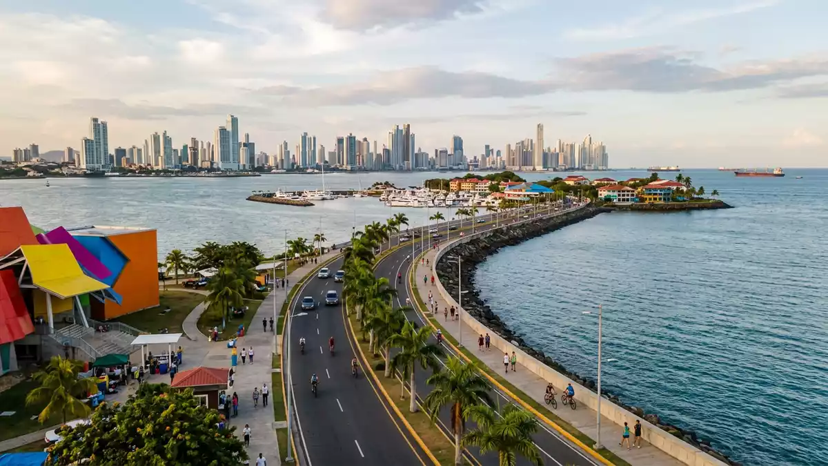
Calzada de Amador in Panama-Stadt is the long waterfront causeway that leads out across Panama Bay towards the Pacific entrance of the Panama Canal, carrying the city over reclaimed ground towards a chain of low islands in the bay. Built in the early twentieth century using rock excavated from the canal’s Culebra Cut, it turns engineering spoil from the isthmus into a seafront roadway flanked by water on both sides.
A strip of canal earth reaching into the Pacific
Seen on a map, Calzada de Amador appears as a narrow arc pushing south-west from Panama-Stadt into the bay, its roadway laid over a core of rock and earth dumped during canal construction. The spoil came from the Culebra Cut, the deep notch driven through the continental divide so ships could cross the isthmus, and the causeway’s structure still rests on this excavated material.Built in 1913 with rock from the Culebra Cut gave the city a solid link from the mainland out towards the Pacific approach to the canal.
As it leaves the shore, Calzada de Amador runs between Panama Bay and the open water beyond the harbour, functioning as both road and breakwater. The structure shields the canal’s southern entrance from the wider bay, while its upper surface carries traffic and visitors out towards the islands. In the process, the causeway connects the city with Naos, Perico, Culebra and Flamenco, four small islands that form a scattered archipelago at the canal mouth.The scenic road links these four islands to Panama City, turning what were once isolated outcrops into extensions of the urban waterfront.
Fort Amador and the canal-era landscape
The story of Calzada de Amador is tied closely to the Panama Canal and the period when the United States administered the canal zone. The causeway and its islands formed part of a wider military landscape, with fortifications established to protect the southern entrance to the canal during the twentieth century.From 1920 to 1980 the area was occupied by a military base known as Fort Amador, one of the installations guarding the Pacific end of the canal.
Across Naos, Perico, Culebra and Flamenco, batteries, service roads and other defensive structures formed part of this complex. The islands were described as fortified, with gun positions and other facilities overlooking shipping lanes at the canal approach.Fort Amador used the linked islands as a platform defending the Canal’s Pacific entrance, and Calzada de Amador connected these positions directly to the mainland.
From canal infrastructure to waterfront promenade
Although Calzada de Amador began as a piece of canal infrastructure and military access, its long, low roadway along the water has become one of Panama-Stadt’s prominent seafronts. The raised strip of land and asphalt offers views back towards the city skyline, across the bay towards the Bridge of the Americas, and out towards the shipping route that leads into the locks. With water on either side, the causeway feels distinct from the inland streets and gives Panama-Stadt a linear promenade reaching into the bay.
At the islands, Calzada de Amador meets marinas, waterfront walks and cultural sites, reflecting a shift from strategic outpost to recreational area described in accounts of the canal handover.Following Panama’s assumption of canal control, the causeway became a public recreation area, and the islands moved from exclusive military use to part of the city’s wider waterfront.
Visiting Calzada de Amador: what travellers from Western Europe should know
- Calzada de Amador extends south-west from Panama-Stadt along Panama Bay towards the Pacific entrance of the Panama Canal, linking the mainland with the small islands of Naos, Perico, Culebra and Flamenco by road.
- The causeway itself is a raised strip of reclaimed land and asphalt, with the roadway running between the bay and the open water; walking or cycling along it involves covering a considerable linear distance on an exposed waterfront route.
- Calzada de Amador lies within Panama, where the official language is Spanish and the currency is the balboa, alongside the US dollar in circulation.
- Entry requirements depend on your nationality; UK travellers can check the FCDO travel advice at gov.uk/foreign-travel-advice, Irish travellers the Department of Foreign Affairs at ireland.ie.
Searching for Calzada de Amador on social platforms
These links open searches for Calzada de Amador on each platform.
Frequently asked questions about Calzada de Amador
Where is Calzada de Amador?
Calzada de Amador is a causeway in Panama-Stadt, Panama, extending from the city’s Pacific waterfront across Panama Bay towards the entrance of the Panama Canal and linking the mainland to the islands of Naos, Perico, Culebra and Flamenco.
What should visitors expect on a visit to Calzada de Amador?
Visitors encounter a long waterfront roadway built on canal excavation rock, with views over Panama Bay, the canal approach and the city skyline, and access to the small islands connected by the causeway.
What makes Calzada de Amador distinctive among Panama-Stadt’s waterfronts?
Calzada de Amador is distinctive because it combines a breakwater built from Culebra Cut excavation with a causeway linking fortified islands such as those once occupied by Fort Amador, creating a linear seafront directly tied to the canal era.


