
Calzada de Amador, Panama-Stadt’s road on rock and islands
Published on 09/17/2026 at 22:36 | Editorial responsibility: Rafael Müller, Editor-in-Chief AD HOC NEWS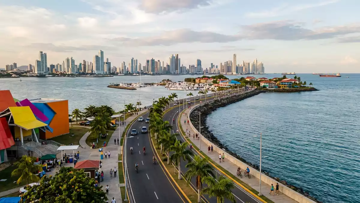
Calzada de Amador in Panama-Stadt is a long man-made causeway of rock and asphalt that carries a waterfront road out into the Pacific Ocean, linking the mainland to a small archipelago at the Pacific entrance to the Panama Canal. Built in the early twentieth century using material excavated during construction of the canal, it has shifted from military breakwater to waterfront promenade, with Panama’s skyline on one side and the open bay on the other.
A strip of land between city, canal and islands
Calzada de Amador is a roadway that connects the continental edge of Panama-Stadt with a chain of low islands in the Pacific, forming a narrow strip of land that functions both as sea defence and as access route. The causeway begins near the southern entrance of the Panama Canal in the Ancón area of the city and runs out towards the bay, separating the sheltered waters of the canal approach from the wider Pacific. The road links the mainland with at least three named islands, Naos, Perico and Flamenco, which together form a small archipelago at the mouth of the canal.connects the continental edge The alignment of the causeway, curving out into the ocean, gives direct views of the Bridge of the Americas, the shipping lanes leading into the canal and the towers of Panama-Stadt behind.
The structure itself is substantial: sources describe Calzada de Amador as extending for about 6 km (3.7 miles) from the mainland, creating a long waterfront that carries both a road and recreational areas along its length.extends for about 6 km The islands linked by the causeway have differing characters: Naos is associated with scientific and nature facilities, Perico has marinas and boat services, and Flamenco has more extensive visitor infrastructure such as a marina and commercial spaces.the islands linked by the causeway
From canal construction to waterfront promenade
Calzada de Amador was constructed in the era when the Panama Canal itself was being built, and its material is directly linked to that project. Documentation describes the causeway as built around 1913 by the United States administration using rock and soil excavated from the Culebra Cut, the major inland cutting that formed part of the canal route.built around 1913 by the United States administration In early decades it formed part of a broader military complex known as Fort Amador, established to help protect the Pacific entrance of the canal and to serve the wider Canal Zone.
The use of Calzada de Amador has changed over the twentieth century and into the twenty-first. Initially, access was largely restricted to United States military authorities and installations on the islands, with fortifications and defence structures built to guard the canal approach.access was largely restricted Later, political agreements such as the Torrijos–Carter Treaties in 1977 led to the gradual transfer of these lands to Panama, and the area evolved from a largely military zone into a public waterfront. Calzada de Amador is now described as one of Panama-Stadt’s recognised recreational and tourist areas, combining its function as breakwater with uses that include walking, cycling and visiting the islands.recognised recreational and tourist areas
Experiencing Calzada de Amador on foot or wheels
Visitors encounter Calzada de Amador as both transport corridor and open-air promenade, with the sea on several sides and long views across Panama Bay. The road itself carries general traffic, but descriptions emphasise jogging and cycling paths that run alongside it, making it a place where people move at slower pace close to the water. As the causeway approaches the islands, the mainland skyline eases into marinas, piers and small harbours, with boats moored along the shoreline and occasional vantage points over the canal entrance.jogging and cycling paths
The combination of road, sea and islands gives Calzada de Amador a distinct spatial character among Panama-Stadt’s public spaces. On one side lie the port and canal approaches, with commercial ships lining up to enter the locks; on the other side the open bay reaches towards islands such as Taboga in the distance. The strip of land formed by the causeway is relatively narrow, so the waterfront and the carriageway sit close together, interspersed with planted areas and paved walkways. After decades of transformation, traces of earlier military use coexist with newer visitor-oriented facilities, offering a mix of historic context and present-day leisure along the same stretch of rock and asphalt.mix of historic context and leisure
Visiting Calzada de Amador: what travellers from Western Europe should know
- Calzada de Amador runs from the western side of Panama-Stadt towards the Pacific entrance of the Panama Canal, starting near the Ancón area and reaching islands including Naos, Perico and Flamenco.
- The terrain along the causeway is mostly level, with long paved walkways beside the road; distances between points of interest can involve extended stretches on foot or by bicycle.
- Calzada de Amador can be reached from central Panama-Stadt by road; public transport routes from the Albrook area serve the causeway and its islands.
- The official language is Spanish and the currency is the balboa, which is pegged to the US dollar.
- Entry requirements depend on your nationality; UK travellers can check the FCDO travel advice at gov.uk/foreign-travel-advice, Irish travellers the Department of Foreign Affairs at ireland.ie.
Searching for Calzada de Amador on social platforms
These links open searches for Calzada de Amador on each platform.
Frequently asked questions about Calzada de Amador
Where is Calzada de Amador located?
Calzada de Amador is in Panama-Stadt, Panama, beginning near the Ancón district at the Pacific entrance of the Panama Canal and extending out towards nearby islands.
What can visitors expect on a visit to Calzada de Amador?
Visitors can expect a long waterfront road with paved walkways beside the sea, views of the canal entrance and city skyline, and access to islands with marinas and other facilities.
What makes Calzada de Amador distinctive among Panama-Stadt’s waterfronts?
Calzada de Amador is distinctive because it is built on rock excavated during construction of the Panama Canal and connects the mainland to several offshore Pacific islands along a single causeway.


