
Canon del Sumidero, the vertical canyon of Chiapa de Corzo
Published on 09/18/2026 at 16:35 | Editorial responsibility: Rafael Müller, Editor-in-Chief AD HOC NEWS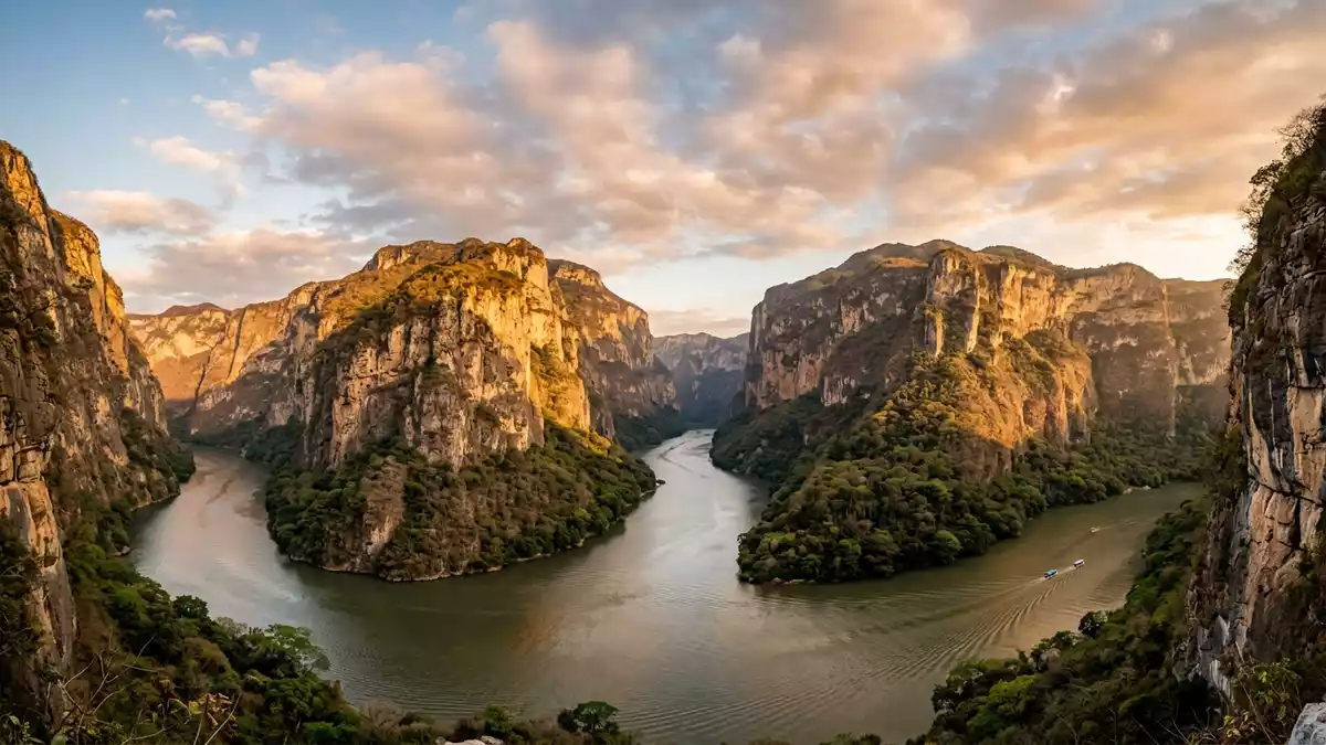
Canon del Sumidero is a steep-walled canyon carved by the Grijalva River just north of Chiapa de Corzo in the southern Mexican state of Chiapas, a landscape where high rock walls frame a long, narrow water corridor.Sumidero Canyon The gorge lies within a protected area known as Parque Nacional Cañón del Sumidero, established in 1980 as a national park.Parque Nacional Cañón del Sumidero
A canyon of height, water and rock
The defining impression of Canon del Sumidero is the height and steepness of its rock faces above the Grijalva River, which in places rise around 1,000 m (3,281 ft) from the water to the rim.sheer height of its rock walls The canyon cuts through the mountains of central Chiapas along a course of roughly 30 km, narrowing to stretches where the river channel is closely hemmed in and opening out again towards its northern end.extensión aproximada de 30 kilómetros Boat journeys on the Grijalva reveal vertical cliffs broken by ledges, caves and recesses where the rock face changes character.
The bedrock of Canon del Sumidero includes extensive Jurassic and Cretaceous limestone, with basaltic formations also present along the canyon walls.calizas macizas del Jurásico y Cretácico Over geological time the Grijalva River has cut down through these layers, creating deep escarpments and a profile where high cliffs give way to forested slopes and riverbanks along the canyon floor.acantilado que se eleva sobre el cauce The river continues to flow along the gorge, linking the wider Grijalva basin to a reservoir formed by a hydroelectric dam at the upper end.
From Chiapa de Corzo to the Chicoasén reservoir
Canon del Sumidero begins near Chiapa de Corzo, where the Grijalva River enters the mouth of the canyon just north of the town.en su boca sur, el cañón inicia en Chiapa de Corzo The gorge then runs northwards through the mountains before reaching the Chicoasén hydroelectric dam, officially named Manuel Moreno Torres, at its upper end.Chicoasén-dam Impoundment of the Grijalva in the early 1980s created a reservoir that extends back through the canyon, turning its northern stretches into a long lake framed by steep cliffs.Chicoasén hydroelectric dam
On land, Canon del Sumidero lies between Tuxtla Gutiérrez and Chiapa de Corzo, in a park whose protected area spans several municipalities in central Chiapas.municipios de Tuxtla Gutiérrez, Chiapa de Corzo A scenic road climbs from Tuxtla Gutiérrez along the Calzada al Sumidero towards viewpoints on the canyon rim, where miradores look out over the Grijalva far below.Calzada al sumidero Km 5 From the river level, access points near Chiapa de Corzo and the locality of Cahuaré serve as departure points for boat excursions along the canyon.
Canon del Sumidero as a protected landscape
Parque Nacional Cañón del Sumidero was created in 1980 as a national park in Chiapas, recognising the canyon as a landscape of ecological and geological importance.established in 1980 The protected area has been listed under the Ramsar Convention as a wetland of international importance, reflecting the value of its river corridor and associated habitats.Ficha Informativa de los Humedales de Ramsar Within its boundaries, cliffs, forested slopes, riverbanks and smaller ravines combine to create varied microenvironments along the canyon.
The national park covers tens of thousands of hectares and encompasses both the steep core of the canyon and surrounding highlands, with the Grijalva River running as a central axis.21,789 hectares in five municipalities From the water, the sense of enclosure is strong where the channel passes close beneath the cliffs; from the rim viewpoints, the canyon appears as a deep incision through otherwise undulating terrain. The combination of high rock faces, a long waterway and protected status makes Canon del Sumidero a distinct landscape within Chiapas.
Visiting Canon del Sumidero: what travellers from Western Europe should know
- Canon del Sumidero lies in Chiapas in southern Mexico, with river access from Chiapa de Corzo and road access to rim viewpoints from Tuxtla Gutiérrez via the Calzada al Sumidero.
- Boat excursions along the Grijalva River run between steep canyon walls, with boarding points at riverside docks near Chiapa de Corzo and in the locality of Cahuaré.
- The canyon environment combines high cliffs with stretches of forested slope and riverbank, and some viewpoints on the rim are reached by road followed by short walks.
- The official language is Spanish and the currency is the Mexican peso.
- Entry requirements depend on your nationality; UK travellers can check the FCDO travel advice at gov.uk/foreign-travel-advice, Irish travellers the Department of Foreign Affairs at ireland.ie.
Searching for Canon del Sumidero on social platforms
These links open searches for Canon del Sumidero on each platform.
Frequently asked questions about Canon del Sumidero
Where is Canon del Sumidero located?
Canon del Sumidero is in the state of Chiapas in southern Mexico, just north of the town of Chiapa de Corzo and close to the city of Tuxtla Gutiérrez.
What can visitors expect when they visit Canon del Sumidero?
Visitors encounter a deep canyon with high rock walls above the Grijalva River, viewed either from boats travelling along the waterway or from rim viewpoints reached by road.
What makes Canon del Sumidero distinctive among Mexican landscapes?
Canon del Sumidero is distinctive for its combination of steep cliffs rising hundreds of metres above a river corridor, its length through the Chiapas mountains and its designation as a national park.


