
Canon del Sumidero, where the Grijalva River carves Chiapas
Published on 09/19/2026 at 10:56 | Editorial responsibility: Rafael Müller, Editor-in-Chief AD HOC NEWS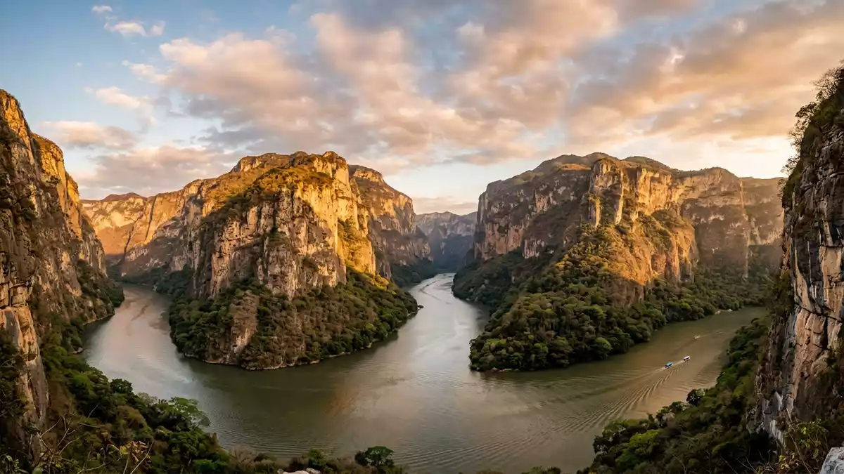
Canon del Sumidero, known in Spanish as Cañón del Sumidero, is a deep river gorge in the Mexican state of Chiapas, just north of Chiapa de Corzo, where the Grijalva River cuts through limestone cliffs in a protected national park landscape.
Canon del Sumidero as a river canyon in central Chiapas
Canon del Sumidero lies in southern Mexico within Chiapas, immediately north of the colonial town of Chiapa de Corzo and close to the state capital Tuxtla Gutiérrez, in the region often described as the Chiapas Depression, where the Grijalva River occupies a narrow valley between uplands.Sumidero Canyon The canyon forms part of a wider protected area known as Parque Nacional Cañón del Sumidero, which extends across several municipalities around Tuxtla Gutiérrez and Chiapa de Corzo and safeguards the steep river corridor and surrounding hillsides as a conservation zone.Parque nacional Cañón del Sumidero
The canyon itself is a geological fault-like incision where the Grijalva River has eroded into limestone and other sedimentary rocks over millions of years, leaving walls that rise hundreds of metres above the water and create a relatively short but dramatic corridor north of Chiapa de Corzo.walls that rise up to 1000 meters The protected park status, formalised by regional decrees in the twentieth century, frames Canon del Sumidero not only as a scenic attraction but also as a site of geological interest and biodiversity along one of Mexico’s significant rivers.official protection
Limestone cliffs, river bends and viewpoints
Seen from the water, Canon del Sumidero presents sheer limestone faces that rise high above the river, exposing layers formed from marine sediments and calcium minerals that began accumulating more than 100 million years ago when this part of Chiapas lay beneath a shallow sea.rocks began to form about 136 million years ago Tectonic movements associated with horst and graben structures later lifted these rocks, and the Grijalva River cut down through them, creating cliffs that can reach around 1,000 m (3,281 ft) above the water surface in some sections and a gorge whose width varies between roughly 1 and 2 km (0.6 to 1.2 miles).depths of up to 3,000 feet
Along the rim of Canon del Sumidero, a series of road-accessible viewpoints on the high ground near Tuxtla Gutiérrez allow visitors to look down into the gorge and trace the path of the Grijalva as it makes marked bends between the cliff faces, while boat trips from Chiapa de Corzo and nearby embarkation points follow the river through the canyon itself between vertical rock walls and occasional side ravines.miradores del cañón The upper plateau around the canyon supports mixed vegetation, while the cliff ledges and riverbanks provide habitats for birds and other wildlife that can be observed from water level as the boats pass under towering escarpments.
History, protection and the wider Chiapa de Corzo setting
The landscape around Canon del Sumidero has seen human presence for centuries along the Grijalva corridor, with pre-Hispanic communities such as the Chiapa people occupying settlements near what is now Chiapa de Corzo before Spanish conquest in the sixteenth century, when the river valley functioned as a route between uplands and lowlands.indigenous Chiapa people In the twentieth century the canyon gained formal recognition as an area needing ecological and geological protection, and park designation in the 1970s established Canon del Sumidero National Park as a managed natural area for conservation, scientific study and controlled tourism within central Chiapas.state decree issued in 1972
Canon del Sumidero sits in a broader landscape that includes the reservoir created by the Manuel Moreno Torres hydroelectric dam, widely known as Presa Chicoasén, at the northern end of the canyon, where the river backs up against the dam among surrounding hills, and road links between Tuxtla Gutiérrez and Chiapa de Corzo cross the Grijalva at bridges south of the gorge.embalse artificial de la presa hidroeléctrica Manuel Moreno Torres For visitors from Western Europe, Canon del Sumidero offers a combination of geological scenery, river travel and views over the Chiapas highlands that connect naturally with time spent in Chiapa de Corzo, where the town’s streets and squares sit only a short distance from the Grijalva and the southern mouth of the canyon.
Visiting Canon del Sumidero: what travellers from Western Europe should know
- Canon del Sumidero lies in Chiapas in southern Mexico, with access by road from Tuxtla Gutiérrez and Chiapa de Corzo, where embarkation points on the Grijalva River serve boat trips into the canyon.
- The terrain within the gorge is defined by steep limestone cliffs and riverbanks reached by boat, while land-based visits to the upper rim use paved roads and viewpoints on high ground above the canyon.
- Canon del Sumidero is reached within Mexico, where the official language is Spanish and the national currency is the Mexican peso.
- Entry requirements depend on your nationality; UK travellers can check the FCDO travel advice at gov.uk/foreign-travel-advice, Irish travellers the Department of Foreign Affairs at ireland.ie.
Searching for Canon del Sumidero on social platforms
These links open searches for Canon del Sumidero on each platform.
Frequently asked questions about Canon del Sumidero
Where is Canon del Sumidero located?
Canon del Sumidero is in Chiapas in southern Mexico, just north of Chiapa de Corzo and close to Tuxtla Gutiérrez, following a section of the Grijalva River.
What can visitors expect when visiting Canon del Sumidero?
Visitors encounter a deep limestone gorge with high cliffs rising above the Grijalva River, reached by boat from river piers and by roads leading to viewpoints along the canyon rim.
What makes Canon del Sumidero distinctive among river canyons?
Canon del Sumidero is distinctive for its combination of very steep limestone walls, protected national park status and its location beside Chiapa de Corzo within the central Chiapas highlands.


