
Danakil Depression and Dallol’s salt-volcanic landscape
Published on 09/17/2026 at 07:16 | Editorial responsibility: Rafael Müller, Editor-in-Chief AD HOC NEWS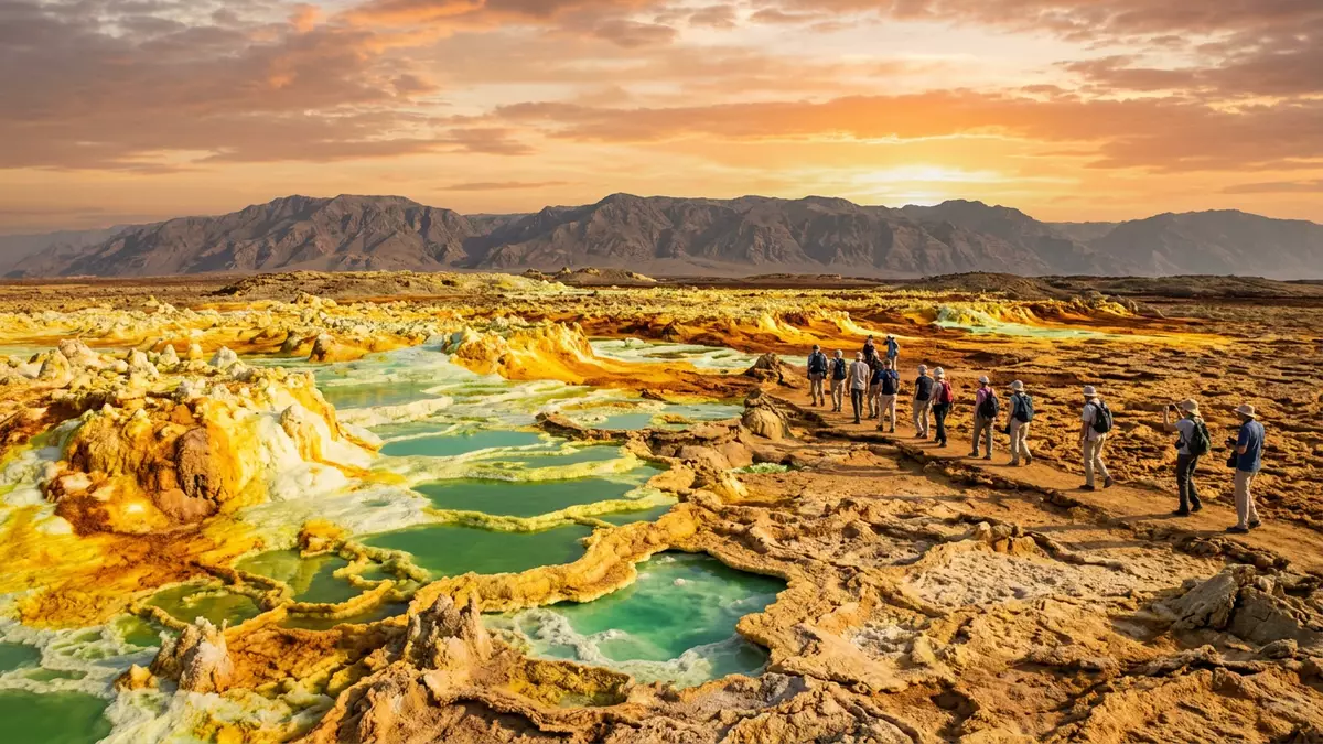
In northern Ethiopia’s Afar Region, the Danakil Depression near Dallol presents one of Earth’s most striking salt-volcanic landscapes, where a deep tectonic basin meets vividly coloured mineral terraces and pools. Set within the broader East African Rift system and part of the Afar Triangle, this low-lying plain sits well below sea level and brings together rift geology, thick evaporite deposits and hydrothermal activity in a way that is hard to forget.
A rift valley carved by moving plates
The Danakil Depression is a north–south elongated basin within the Afar Triangle, lying at the junction between the Nubian, Somalian and Arabian plates and the Danakil microplate.junction of tectonic plates It forms part of the East African Rift system, a chain of rift structures that extends from Mozambique towards the Arabian Peninsula.part of the East African Rift Over geological time, extension between these plates has created a narrow lowland plain, with the depression floor lying around 100 to 120 m below sea level at its deepest points.
Much of the basin is underlain by sedimentary sequences and thick evaporites deposited when marine waters from the Red Sea entered and retreated from the rifted area.thick salt formations The floor of the Danakil Depression includes salt lakes such as Lake Assale, also known as Lake Karum, and wide salt flats occupying the lowest parts of the basin.one of the lowest land areas Around Dallol, this structural basin becomes a stage for salt-volcanic features created where heat and fluids interact with the evaporite cover.
Dallol dome and its hydrothermal field
Dallol itself is an uplifted dome rising tens of metres above the surrounding salt flat in the northern part of the Danakil Depression.uplifted dome in the salt plain The dome structure resembles a low shield, built not of lava flows but of bedded halite and anhydrite that have been pushed upwards and gently tilted outwards.bedded halite and anhydrite layers Around its flanks, the salt flat stretches out as a broad white surface, hinting at the thickness of evaporites beneath.
On and around this dome lies the Dallol hydrothermal system, with springs, brine pools, geysers and salt chimneys built by mineral-rich fluids emerging through the salt sequence.hydrothermal features at Dallol The fluids interact with salts and other minerals to create terraces, pillars and crusts in shades of yellow, orange, white and green that have made the area a reference point for “polyextreme” environments in Earth science.
Colours, minerals and the salt-flat setting
One of the most striking aspects of Dallol within the Danakil Depression is the palette of colours formed by its mineral chemistry. Halite, jarosite, hematite, gypsum, anhydrite, sylvite and carnallite are among the minerals associated with the site, combining with acidic brines and evaporation to produce vividly coloured crusts and pools on the surface.minerals associated with Dallol The view across the terraces can shift from sulphur-rich yellow to iron-stained red and greenish waters within a few steps.
Beyond the dome, the wider Danakil Depression floor shows basalt flows, shield volcanoes, cinder cones and extensive salt flats created by repeated flooding and evaporation cycles linked to the Red Sea and regional drainage.rift valley salt flats and volcanism In combination, the depression, salt plains and Dallol’s hydrothermal field make this corner of Ethiopia a place where rift tectonics, evaporite geology and active surface processes are visible at human scale.
Visiting Danakil Depression: what travellers from Western Europe should know
- The Danakil Depression and Dallol lie in Ethiopia’s Afar Region, close to the border with Eritrea, reached from towns in northern Ethiopia by road and organised transport.
- Approaches around Dallol involve travel across salt flats and uneven mineral crusts, with sections on foot over rough surfaces and areas shaped by hydrothermal activity.
- The broader landscape combines low elevation below sea level with desert terrain; visits commonly link Dallol with nearby salt lakes and volcanic areas in the Danakil basin.
- The official language is Amharic and the currency is the Ethiopian birr.
- Entry requirements depend on your nationality; UK travellers can check the FCDO travel advice at gov.uk/foreign-travel-advice, Irish travellers the Department of Foreign Affairs at ireland.ie.
Searching for Danakil Depression on social platforms
These links open searches for Danakil Depression on each platform.
Frequently asked questions about Danakil Depression
Where is the Danakil Depression and Dallol located?
The Danakil Depression and Dallol are in Ethiopia’s Afar Region, in the northern part of the Afar Triangle near the border with Eritrea.
What can travellers expect when visiting Dallol?
Travellers encounter a low-lying salt plain, an uplifted dome and a hydrothermal field with mineral terraces, pools and chimneys set within a broader desert rift landscape.
What makes the Danakil Depression distinctive?
The combination of deep rift basin, thick salt formations, active volcanism and Dallol’s vividly coloured hydrothermal features gives the Danakil Depression a character rarely seen elsewhere.


