
Danakil Depression near Dallol: a rift valley of salt and fire
Published on 09/21/2026 at 09:07 | Editorial responsibility: Rafael Müller, Editor-in-Chief AD HOC NEWS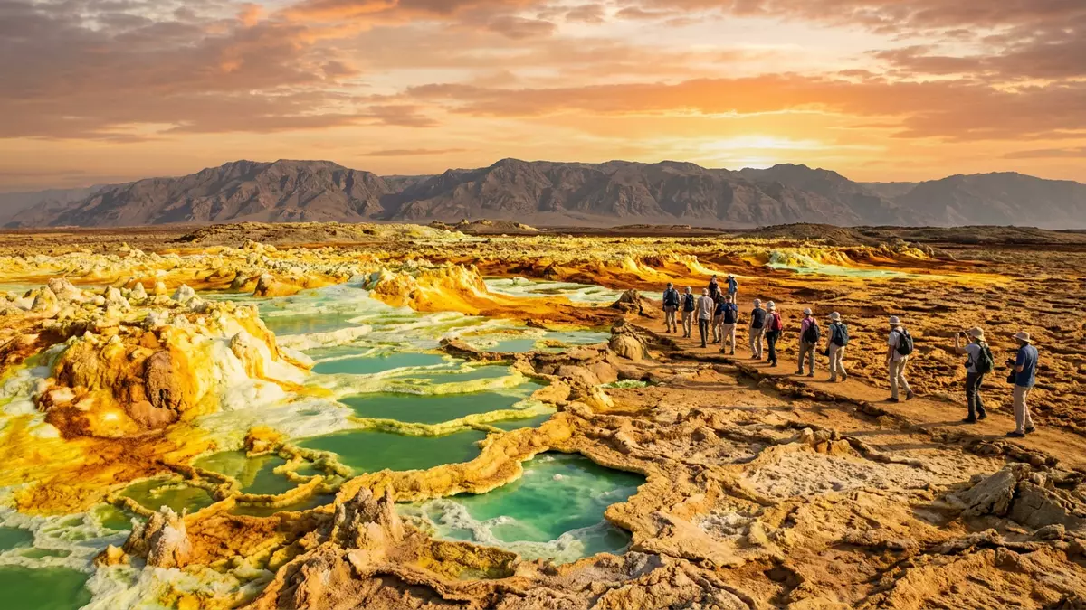
In the far north-east of Ethiopia, the Danakil Depression near Dallol presents a landscape in which salt flats, volcanic cones and hydrothermal springs share the same low-lying rift valley. This part of the Afar region forms one of Earth’s notable below-sea-level basins, with the Dallol area rising only modestly above the surrounding salt plain.
Where Danakil Depression sits in Africa’s tectonic puzzle
The Danakil Depression lies in the Afar region of Ethiopia, close to the border with Eritrea, and forms part of the wider Afar Depression at the northern end of the East African Rift system.Afar region of Ethiopia This broad tectonic setting brings together the Nubian, Somali and Arabian plates, which diverge in a triple junction that has produced a landscape of rift valleys, volcanoes and thin continental crust.junction of the Nubian, Somali, and Arabian plates
Geologically, the Danakil Depression is a rift basin where the extension between the Nubian plate and the Danakil microplate has created a narrow lowland plain around 250 km long, much of it lying significantly below sea level.narrow, arid lowland plain The basin holds thick successions of evaporites, including halite and potash-bearing layers, deposited when arms of the Red Sea became isolated and left behind salt-rich sediments.evaporite depocenter near Dallol
Dallol and the salt plains of northern Danakil
Near the northern end of the Danakil Depression lies Dallol, an uplifted dome structure set within a broad salt pan that forms one of the deepest parts of the basin, reaching well below sea level in places such as Lake Assale.Dallol is an uplifted dome structure The dome rises tens of metres above the surrounding salt flat, creating a modest relief in an otherwise level expanse of halite crust.vast salt plain composed of thick evaporites
Across the salt plains around Dallol, evaporite deposits several hundred metres thick are interbedded with volcanic units from the neighbouring Erta Ale range, giving the surface a patchwork of pale salt, darker basalt and occasional brine pools.evaporites that may underlie the entire depression The impression is of a basin where solidified salt crust, crustal faulting and volcanic intrusions are all visible within a relatively compact area.
Hydrothermal colours and extreme conditions
Dallol itself is a terrestrial hydrothermal system centred on a cinder cone volcano within the evaporitic plain of the Danakil Depression.terrestrial hydrothermal system around a cinder cone volcano The system formed when basaltic magma intruded into Miocene salt deposits, resulting in a salt dome structure where hydrothermally heated waters rise through the evaporites and reach the surface.intrusion of basaltic magma in the marine sedimentary sequence
On the ground this process creates bright hydrothermal springs, brine pools and terraces enriched with sulphur, iron and other elements, producing vivid yellows, greens and ochres on the salt crust.colourful hot springs that are extremely acidic and salty The climate belongs to a hyperarid zone, with high ambient temperatures and very low annual rainfall, and the hydrothermal fluids are highly acidic and saline, making the environment challenging for most forms of life.hydrothermal springs, brine pools, geysers, and salt chimneys
Visiting Danakil Depression: what travellers from Western Europe should know
- Danakil Depression lies in northern Ethiopia’s Afar region, with the Dallol area reached from the Ethiopian plateau towards the low-lying salt plains.
- The terrain around Dallol consists of broad salt flats, uneven crust and sections of rough volcanic rock, so moving around the basin involves walking on hard, irregular surfaces.
- The climate of the northern Danakil Depression is markedly hot and dry, and the exposed salt plains around Dallol offer little natural shade.
- The official language of Ethiopia is Amharic and the currency is the Ethiopian birr.
- Entry requirements depend on your nationality; UK travellers can check the FCDO travel advice at gov.uk/foreign-travel-advice, Irish travellers the Department of Foreign Affairs at ireland.ie.
Searching for Danakil Depression on social platforms
These links open searches for Danakil Depression on each platform.
Frequently asked questions about Danakil Depression
Where is the Danakil Depression near Dallol located?
Danakil Depression lies in the Afar region of north-eastern Ethiopia, close to the border with Eritrea, with Dallol in its northern sector.
What kind of landscape should visitors expect in the Dallol area?
The landscape combines low-lying salt flats, a modestly elevated salt dome at Dallol, scattered volcanic cones and brightly coloured hydrothermal springs and terraces.
What makes this part of Danakil Depression distinctive?
The combination of thick evaporite deposits, active rifting and the hydrothermal system around the Dallol dome gives the northern Danakil Depression an unusual mix of salt crust, volcanism and striking colours.


