
Gorges du Verdon, the limestone canyon above Moustiers-Sainte-Marie
Published on 09/03/2026 at 20:48 | Editorial responsibility: Rafael Müller, Editor-in-Chief AD HOC NEWS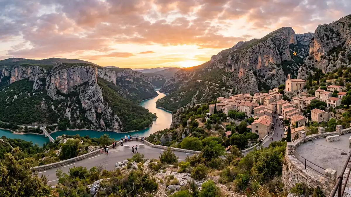
Gorges du Verdon, above the village of Moustiers-Sainte-Marie in south-eastern France, is a limestone river canyon where pale cliffs plunge towards a narrow ribbon of turquoise water. Carved by the Verdon river between the Var and Alpes-de-Haute-Provence departments, it forms a striking boundary between Mediterranean scrubland and the lower Alpine slopes in the Provence-Alpes-Côte d’Azur region.Provence-Alpes-Côte d’Azur
A canyon carved into a limestone plateau
At Gorges du Verdon the landscape is defined by a high limestone plateau split open by the Verdon river, creating a canyon that stretches for about 25 km (15.5 mi) between Castellane and the Lac de Sainte-Croix near Moustiers-Sainte-Marie.stretches for about 25 km Along much of its length the gorge marks the administrative boundary between the Var to the south and Alpes-de-Haute-Provence to the north.boundary between the Var and Alpes-de-Haute-Provence The cliffs rise in places to around 700 m (2,297 ft) above the river, giving the Gorges du Verdon a sense of depth and enclosure uncommon in Western Europe.cliffs can reach 700 metres
The underlying rock is largely limestone, shaped over geological time by water cutting into the plateau and enlarging faults into the steep walls seen today.limestone plateau carved by the Verdon river Standing at one of the roadside viewpoints, the contrast is clear: vertical pale faces shaded by overhangs, scattered vegetation clinging to ledges, and far below the sinuous course of the Verdon flowing towards the Lac de Sainte-Croix. The gorge is commonly divided into sections, with the central stretch between Pont de Soleils and the Imbut known simply as “the Gorges”, and the downstream reach towards Pont de Galetas referred to as “the Canyon”.divided into distinct parts
Routes, viewpoints and the loop from Moustiers-Sainte-Marie
Roads on both rims make Gorges du Verdon accessible without leaving tarmac, and their names have become part of the place’s identity. On the northern side, between Castellane and Moustiers-Sainte-Marie, the departmental road D952 follows the gorge and links into the Route des Crêtes, a loop road with a sequence of high viewpoints over the canyon.Gorges du Verdon and Route des Crêtes On the southern side, another road runs between Aiguines and Castellane; stretches of it are known as the Corniche Sublime, crossing vertical rock and offering views across to the opposite cliffs.Corniche Sublime on the south side
Moustiers-Sainte-Marie functions as one of the gateways to Gorges du Verdon, and road descriptions frequently use it as a starting point. A circular drive of about 130 km (80.8 mi) connects Moustiers-Sainte-Marie with La Palud-sur-Verdon, Trigance, Castellane and Aiguines, combining panoramic stretches, cliff-edge sections and short detours to signed viewpoints above the river.loop of about 130 km From the northern roads the canyon appears as a carved trench running between ridges, while from the southern side attention is drawn to individual buttresses of rock rising above the bends of the Verdon and above the upper reaches of the Lac de Sainte-Croix.
Water, rock and ways into the gorge
Although viewed from above by many travellers, Gorges du Verdon is at heart a river landscape. The Verdon itself, fed from sources near the Col d’Allos in the Alps, flows through a wider valley before tightening into the gorge and ultimately into the reservoir of Lac de Sainte-Croix near Moustiers-Sainte-Marie.river Verdon and Lac de Sainte-Croix The colour of the water is often described as turquoise or emerald, a result of dissolved limestone particles giving a milky vividness against the darker tones of forest and cliffs.
Access into the gorge is structured around established routes on land and water. Trail descriptions refer to paths such as the Blanc-Martel and the Imbut, which descend from the plateau and follow stretches of the canyon close to the river, sometimes using tunnels or stairways cut into the rock.Blanc-Martel or Imbut trails On the water, sections near the Lac de Sainte-Croix are navigated by canoe and kayak, and upstream reaches support organised rafting when levels permit.canoe, kayak or guided rafting Seen from river level, the same cliffs that appear almost abstract from above become vertical walls rising far beyond the treetops lining the banks.
Visiting Gorges du Verdon: what travellers from Western Europe should know
- Gorges du Verdon lies in the Provence-Alpes-Côte d’Azur region of France between the Var and Alpes-de-Haute-Provence departments, with Moustiers-Sainte-Marie and Castellane marking the ends of the main canyon section. Roads such as the D952 and the Corniche Sublime link the gorge to the wider regional network.
- Terrain at Gorges du Verdon includes high limestone rims, steep slopes and sections with stairways and tunnels on the main hiking routes down towards the river, demanding sure footing and comfort with exposure.
- The gorge sits above the Lac de Sainte-Croix, and approach roads pass through rural landscapes of fields, scrub and low hills before reaching the more enclosed canyon stretches.
- The official language is French and the currency is the euro.
Searching for Gorges du Verdon on social platforms
These links open searches for Gorges du Verdon on each platform.Frequently asked questions about Gorges du Verdon
Where is Gorges du Verdon in France?
Gorges du Verdon is in the Provence-Alpes-Côte d’Azur region, forming a boundary between the Var and Alpes-de-Haute-Provence departments between Castellane and Moustiers-Sainte-Marie.
What should visitors expect on a first visit?
Visitors encounter a deep limestone canyon with high cliffs, a turquoise river, rim roads with viewpoints, and paths that descend from the plateau towards the water.
What makes Gorges du Verdon distinctive among European landscapes?
The combination of a long, narrow river gorge up to around 700 m deep, easily reachable rim roads and the position between Alpine foothills and Provence scrub makes Gorges du Verdon distinctive.


