
Grachten van Amsterdam and the seventeenth?century canal ring
Published on 08/18/2026 at 13:06 | Editorial responsibility: Rafael Müller, Editor-in-Chief AD HOC NEWS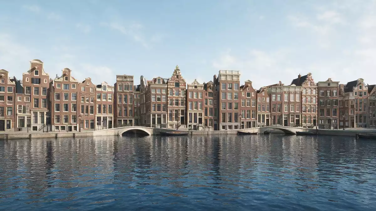
Grachten van Amsterdam are the canals that shape the historic core of Amsterdam, a planned seventeenth?century ring of waterways, streets and houses laid out during the Dutch Golden Age. They form a distinctive urban landscape of brick canal houses, tree?lined quays and linked waterways that define the city’s character.
A planned canal ring from the Dutch Golden Age
The historic canal ring of Amsterdam took form in the seventeenth century, when the city expanded beyond its medieval core and laid out new residential districts along carefully surveyed canals. The main expansion phase began in 1613, when engineers and surveyors started to dig new canals and mark out building plots beyond the old city walls.The development from 1613 created an arc of new neighbourhoods that wrapped around the centre.
The seventeenth?century canal ring area inside the Singelgracht has been formally recognised as a World Heritage Site under the name “Seventeenth?Century Canal Ring Area of Amsterdam inside the Singelgracht”.The UNESCO inscription from 2010 covers an area of several hundred hectares where the planned canals and their canal houses survive largely intact. This protected zone follows the sweep of the canals between the Brouwersgracht in the north and the Amstel river to the south and east.The World Heritage site boundaries reflect the seventeenth?century layout.
The four principal canals and their canalside houses
Within Grachten van Amsterdam, four canals form the core of the historic ring: the Singel, Herengracht, Keizersgracht and Prinsengracht. The Singel began as a defensive moat around the medieval city in the fifteenth century, later becoming the inner boundary of the canal belt.The Singel’s role as an early moat marks it out from the younger canals beyond.
Herengracht, Keizersgracht and Prinsengracht were dug in the seventeenth century as part of the Golden Age expansion and became the principal residential and commercial canals of the city.The three main seventeenth?century canals describe broad curves around the centre, lined with canal houses built in brick, many with gabled roofs and decorative façades. Along these quays, successive generations added warehouses, merchants’ houses and more modest dwellings, creating an almost continuous frontage of narrow plots facing the water.
Scale, geometry and water in the canal landscape
The network of Grachten van Amsterdam extends over more than 100 km (62 mi) of canals, with around 90 islands linked by over 1,500 bridges.The length of canals and number of bridges give Amsterdam a dense water grid with frequent crossings. The seventeenth?century canal ring itself occupies an area of several hundred hectares inside the Singelgracht, structured as arcs of canals crossed by radials such as Brouwersgracht, Leliegracht, Leidsegracht and Reguliersgracht.The cross?canals within the ring create short vistas terminated by bridges and façades.
Seen from street level, this geometry translates into repeated sequences of water, quay and house frontage. Trees line many stretches of canal, softening the brick architecture and placing foliage between façades and water.The tree?lined quays distinguish Amsterdam’s canals from many older European waterway cities. Bridges punctuate this landscape at short intervals, some carrying main streets and others narrower lanes, and together they make the canal ring highly permeable on foot.
Visiting Grachten van Amsterdam: what travellers from Western Europe should know
- Grachten van Amsterdam form a canal network around the historic centre of Amsterdam, with the main seventeenth?century ring lying inside the Singelgracht and reached easily on foot from Amsterdam Centraal station.
- The canal ring is largely flat, with quays and streets at low elevation; many bridges have steps, and some stretches of canal are reached by narrow pavements beside the water.
- The city lies in the Netherlands, where the official language is Dutch and the currency is the euro.
Searching for Grachten van Amsterdam on social platforms
These links open searches for Grachten van Amsterdam on each platform.
Frequently asked questions about Grachten van Amsterdam
Where are Grachten van Amsterdam located?
Grachten van Amsterdam are the canals in and around the historic centre of Amsterdam, with the recognised seventeenth?century canal ring lying inside the Singelgracht.
What can visitors expect when exploring the canals?
Visitors encounter a landscape of brick canal houses, tree?lined quays, frequent bridges and interlinked waterways forming arcs and cross?canals around the city centre.
What makes Grachten van Amsterdam distinctive among European cities?
The seventeenth?century canal ring combines a planned semicircular network of canals and streets with extensive canal?front architecture, recognised as a World Heritage Site for its historic urban layout.


