
Grachten van Amsterdam and the seventeenth-century canal ring
Published on 09/18/2026 at 13:20 | Editorial responsibility: Rafael Müller, Editor-in-Chief AD HOC NEWS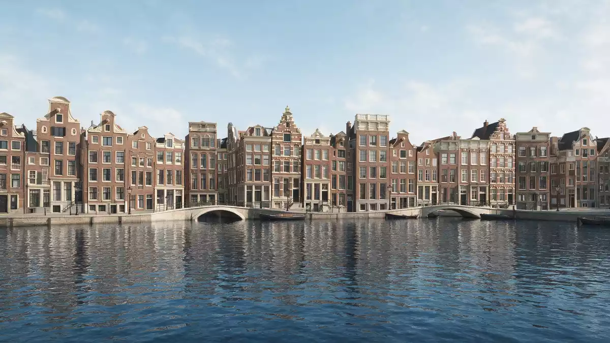
Grachten van Amsterdam are the intertwined canals that define the historic core of Amsterdam, laid out as a planned ring in the seventeenth century during the Dutch Golden Age. The canal district, formally recognised as the Seventeenth-Century Canal Ring Area of Amsterdam inside the Singelgracht, is inscribed as a UNESCO World Heritage Site and turns water into the organising grid of the city’s old neighbourhoods.Seventeenth-Century Canal Ring
A planned water city from the Dutch Golden Age
The Amsterdam canal ring grew out of a deliberate urban extension in the seventeenth century, when the city expanded beyond its medieval core and needed a new framework for streets, housing and water management.planned semicircular ring of canals The result was a semi-circular layout of canals and streets, radiating from the IJ waterfront and wrapping around the older centre in broad arcs. Between these arcs, builders laid out orderly plots for merchant houses, warehouses and smaller alleys, so that every address sat close to a canal quay.
The four principal waterways of this ring are Singel, Herengracht, Keizersgracht and Prinsengracht, together forming a belt that is widely referred to as the Grachtengordel.Amsterdamse grachtengordel Singel traces the inner edge of the ring, following the line of the former medieval moat, while Herengracht, Keizersgracht and Prinsengracht curve further out through what became the main residential and commercial quarters.Herengracht, Keizersgracht and Prinsengracht As a visitor, standing at a canal junction gives a clear sense of this geometry: long, straight stretches vanish into perspective, while cross streets stitch water and land into a single urban fabric.
Main canals, bridges and characteristic houses
Herengracht, sometimes translated as “Gentlemen’s Canal”, became the address for many of Amsterdam’s wealthiest regents and merchants in the seventeenth century, and its canal houses still line the water with deep plots and restrained façades.Herengracht as principal canal Keizersgracht, the central of the three outer canals, carries the name of Maximilian I, the Holy Roman Emperor whose crown appears in the city’s coat of arms, and Prinsengracht runs further out, taking its name from the Prince of Orange.Emperor’s Canal and Prince’s Canal Each canal has its own rhythm of bridges, house fronts and side streets, so that walking along them feels like moving through parallel bands of the same historical pattern.
Across the wider city, the canal system runs to more than 100 km (62 mi) of waterways and crosses around 90 islands and numerous bridges.over 100 kilometres of canals The canal houses rising from these quays are typically narrow at the front and stretch far back from the street, often with ornate gables that reflect the architectural fashion of the era in which they were built.Amsterdamse grachten in the centre Many plots retain lifting beams or hooks at the top, reminders of their use as merchant premises, where goods once moved in and out of upper storeys by hoist rather than staircase.
From medieval moat to World Heritage canal district
Before the seventeenth-century expansion, Amsterdam’s core was enclosed by defensive waterways such as Singel and Kloveniersburgwal, which formed a protective ring around the medieval town.medieval moat around the centre In the seventeenth century the city pushed beyond this line, and new canals extended the urban area in a controlled pattern that balanced access to water with space for building. Some of the oldest surviving canals, such as Oudezijds Voorburgwal and Oudezijds Achterburgwal, date back to the fourteenth century and still thread through the old town, contrasting shorter medieval alignments with the longer seventeenth-century axes.older grachten dating to the fourteenth century
In 2010 the canal ring inside the Singelgracht was added to the UNESCO World Heritage List, recognising its status as a well-preserved example of planned urban development from the Dutch Golden Age.added to the UNESCO list in 2010 The protected area covers hundreds of hectares of waterways, streets and plots, tracing the seventeenth-century design as it survives within the modern city.protected canal ring inside the Singelgracht For travellers, this inscription underlines that walking or boating through Grachten van Amsterdam is not only a way of seeing Amsterdam’s houses from the water but also of traversing a historic planning concept that still orders everyday life.
Visiting Grachten van Amsterdam: what travellers from Western Europe should know
- Grachten van Amsterdam encircle the historic centre of Amsterdam, south and west of Dam Square, and can be reached easily on foot from Amsterdam Centraal railway station.
- The canal district is largely flat, but exploring it on foot involves frequent short bridge climbs and descents, along with cobbled or brick pavements beside the water.
- Historic canal houses stand directly at the quays, so narrow pavements and bridge approaches require attention, especially where pedestrians, bicycles and trams share space.
- Some canal corridors open towards the River IJ and the Amstel, giving long views along the water; others thread between tightly built rows of houses and trees.
- The official language is Dutch and the currency is the euro.
Searching for Grachten van Amsterdam on social platforms
These links open searches for Grachten van Amsterdam on each platform.Frequently asked questions about Grachten van Amsterdam
Where are Grachten van Amsterdam located?
Grachten van Amsterdam form a canal ring around the historic centre of Amsterdam in the Netherlands, concentrated inside and around the Singelgracht.
What should travellers expect when exploring the canals?
Travellers encounter long, straight canal corridors edged by historic houses, frequent bridges, narrow pavements and views that reveal the seventeenth-century layout of the city.
What makes Grachten van Amsterdam distinctive?
The canals combine a seventeenth-century planned urban grid, characteristic canal houses and a recognised UNESCO World Heritage district, making water the organising element of Amsterdam’s old core.


