
Gunung Bromo and the Sea of Sand above Probolinggo
Published on 09/18/2026 at 12:54 | Editorial responsibility: Rafael Müller, Editor-in-Chief AD HOC NEWS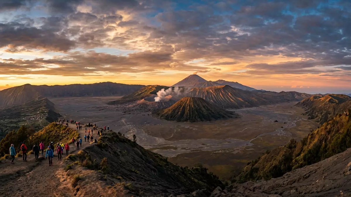
Gunung Bromo stands as an active volcanic cone inside the wide Tengger caldera in East Java, with Probolinggo as one of the nearest urban gateways. Its smoking crater, broad slopes and setting in a vast plain of volcanic sand give it a stark, open character that is unusual even within Indonesia’s long arc of volcanic landscapes. At around 2,329 m (7,641 ft) above sea level, it is a highland environment but not the tallest summit in the region, and its identity is tied less to altitude than to the amphitheatre of rock and sand around it.
A volcanic cone inside a vast caldera
Gunung Bromo is part of the Tengger volcanic complex in East Java, where a large, ancient caldera holds several younger cones on its floor.Bromo Tengger Semeru National Park The caldera itself extends for many kilometres, and within it rise named volcanoes including Mount Bromo at 2,329 m (7,641 ft), Mount Batok, Mount Kursi, Mount Watangan and Mount Widodaren.the five volcanoes inside the Tengger caldera The wide, level floor of this caldera is covered in black volcanic material known as the Tengger Sand Sea, a protected sandy plain that lies at roughly 2,100 m (6,890 ft) and surrounds the cones on all sides.
The Tengger Sand Sea has an extent measured in thousands of hectares at high altitude, forming a broad plateau of ash and sand between the enclosing walls of the old caldera and the cluster of younger peaks.the Tengger Sand Sea protected since 1919 Gunung Bromo rises from this plain as the youngest and only active cone within the caldera, and its crater stands about 200 m above the surrounding sand, with the rim high enough to give wide views across the complex.height above the caldera floor and crater dimensions The steep inner slopes and exposed rim make the cone itself a compact, sharply defined summit compared with the more massive flanks of Mount Semeru nearby.
The wider park and Mount Semeru
Gunung Bromo sits within Bromo Tengger Semeru National Park, a protected area recognised for its volcanic terrain and cultural significance.Bromo Tengger Semeru National Park in East Java The park covers more than 800 km² (about 320 square miles), taking in highlands that range broadly from around 1,000 m to 3,676 m above sea level.extent and elevation range of the park Within these boundaries lie the Tengger Sand Sea, several volcanic cones, rivers and lakes, and the steep outer walls of the caldera that frame the inner basin from above.
The tallest peak in the park, Mount Semeru, reaches about 3,676 m (12,060 ft) and stands to the south of Gunung Bromo as the highest mountain on Java.Mount Semeru as the highest mountain in Java Semeru is an active stratovolcano, with a steep, symmetrical profile that contrasts with the lower, broader shape of Bromo’s cone on the caldera floor. The combination of Semeru’s high summit, the ring of caldera walls and the sandy plateau dotted with smaller volcanoes gives the area a layered appearance: high skyline peaks, mid-level crater rims and low, sandy expanses at the centre, all within a single protected landscape.
Activity, crater and surrounding sand
Geologically, Gunung Bromo is a cinder cone with its crater open at the top and active venting from within.cinder cone classification and location The cone lies at geographic coordinates given for Cemoro Lawang in the Probolinggo administrative area, placing it squarely within East Java’s volcanic belt. Historical records compiled by volcanology programmes list more than 30 eruptive periods since 1900, with the volcano known for intermittent ash plumes, gas-and-steam emissions and short explosive events separated by quieter phases with only fumaroles visible.eruption history of Bromo within the Tengger caldera
The crater rim of Gunung Bromo encircles a steep-sided hollow, and paths reach the edge where volcanic gases and occasional ash rise from the opening. Around the cone, the Tengger Sand Sea stretches as a flat, grey-black expanse of volcanic debris, with fine material underfoot and low undulations instead of vegetation.description of the Sea of Sand and caldera size From the sand plain, the inner volcanoes stand as isolated forms, their slopes rising directly from the flat ground, while the bounding walls of the caldera climb further beyond them to complete the bowl-shaped enclosure. Temperatures at the top of Mount Bromo are reported in a cool range, with figures between about 5 °C and 18 °C.temperature range near the summit
Visiting Gunung Bromo: what travellers from Western Europe should know
- Gunung Bromo lies in East Java within Bromo Tengger Semeru National Park, with Probolinggo, Pasuruan, Malang and Lumajang as surrounding regencies connected by roads into the highlands.
- The crater rim stands about 200 m (656 ft) above the Tengger Sand Sea, reached by paths and stairways that climb steadily from the sandy caldera floor to the edge of the cone.
- The Tengger Sand Sea is a high plateau of fine volcanic material at around 2,100 m (6,890 ft), where walking involves crossing open ground with little shelter and underfoot surfaces of loose ash and sand.
- The park lies in Indonesia, where the official language is Indonesian and the currency is the rupiah.
- Entry requirements depend on your nationality; UK travellers can check the FCDO travel advice at gov.uk/foreign-travel-advice, Irish travellers the Department of Foreign Affairs at ireland.ie.
Searching for Gunung Bromo on social platforms
These links open searches for Gunung Bromo on each platform.
Frequently asked questions about Gunung Bromo
Where is Gunung Bromo located?
Gunung Bromo is in East Java, Indonesia, inside Bromo Tengger Semeru National Park, with Probolinggo as one of the closest significant towns.
What kind of landscape surrounds Gunung Bromo?
The volcano stands on the floor of the Tengger caldera, surrounded by the Tengger Sand Sea, a high plain of volcanic ash and sand enclosed by steep crater walls.
What makes Gunung Bromo distinctive among Indonesian volcanoes?
Gunung Bromo is the youngest and only active cone within the wide Tengger caldera, rising from a large Sea of Sand with several other named volcanoes nearby.


