
Hierve el Agua and Oaxaca’s petrified waterfalls
Published on 09/24/2026 at 12:22 | Editorial responsibility: Rafael Müller, Editor-in-Chief AD HOC NEWS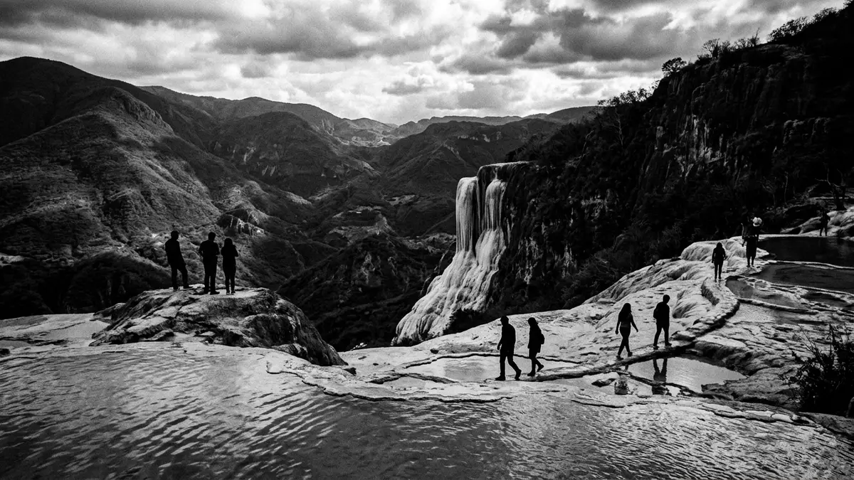
Hierve el Agua is a highland landscape in Oaxaca where mineral-rich springs have built pale travertine over the edge of a mountain. The formations resemble waterfalls frozen in stone, while shallow pools sit beside the cliff and ancient terraces extend across the slopes.
Travertine waterfalls above the Oaxaca valleys
Hierve el Agua lies near San Isidro Roaguía, within the municipality of San Lorenzo Albarradas in Oaxaca, Mexico. Its name means “the water boils”, a reference to the movement of spring water at the vents rather than to its temperature.
The principal formations are made from calcium carbonate deposited by spring water. Rainwater moves through limestone underground, dissolves minerals and emerges through cracks in the mountainside. As the water travels across the exposed rock, mineral deposits accumulate in layers of travertine.
The result is a pale cliff shaped like a cascade, although no large river pours over its edge. One formation rises to about 30 metres, while another reaches roughly 12 metres. The surfaces carry ridges, shelves and channels formed by mineral deposits, with the dry surrounding vegetation providing a contrasting setting.
Two spring-fed pools occupy the upper area. Their water contains calcium carbonate, magnesium and other dissolved minerals. The pools are set beside the cliff formations, linking the visible spring activity with the stone terraces below. mineral-rich spring water explains both the pools and the petrified cascades.
Zapotec terraces and a long water history
Hierve el Agua is also an archaeological landscape associated with the Zapotec people. More than 2,500 years ago, residents created terraces and channels around the springs. The surviving remains extend across steep ground near the formations.
The channels carried water through a system of stone-lined routes and terraced plots. Archaeological work has connected the system with pre-Hispanic water management and agriculture. The terraces preserve a record of how communities used a permanent water source in the mountains above the Valley of Oaxaca.
Research into the site has not treated the channels as a simple decorative feature. Their arrangement, construction and relationship with the springs make Hierve el Agua an important place for studying ancient land use in Oaxaca. The principal archaeological period associated with the water system reaches from the first millennium BC into the first millennium AD.
Dating varies between studies, but construction of the terrace and channel system is placed in the pre-Hispanic era. Some archaeological interpretations date its beginnings to around 700–500 BC, with occupation continuing until about 1350 AD. ancient Zapotec water system remains central to the site’s cultural meaning.
The archaeological evidence also carries an important qualification. Earlier interpretations described the channels mainly as irrigation works, while later research has examined the possibility of salt production through solar evaporation. The terraces and channels are secure features of the landscape; their exact uses belong to a continuing field of study.
A landscape of springs, cliffs and terraces
The setting combines several types of terrain in a compact area. Travertine cliffs occupy the most recognisable edge, spring pools sit on the upper surface, and dry mountain slopes fall away towards the valleys. The exposed rock is pale against scrub vegetation and distant ridges.
The two principal waterfall formations are often identified as Cascada Grande and Cascada Chica. Cascada Grande is the higher formation, while Cascada Chica forms a smaller mineral terrace. Their surfaces show the accumulation of waterborne deposits rather than the erosion of a conventional stream.
Hierve el Agua also belongs to the wider cultural landscape of the Central Valleys of Oaxaca. The nearby town of Mitla provides a route towards the mountain site and forms part of a broader journey through Zapotec archaeology. Oaxaca’s valleys contain settlements, craft traditions and ceremonial remains that place the springs within a substantial regional history.
The state of Oaxaca designated Hierve el Agua as an ecological reserve and state park in 1997. state park designation forms part of the place’s modern legal identity, while the springs, terraces and mineral cliffs retain their older geographical and archaeological character.
The landscape therefore joins living water with stone records. Springs continue to emerge beside deposits formed over long periods, and the terraces preserve human alterations across the same mountain slopes. Hierve el Agua is a place where a visible waterfall shape is geological, while the surrounding channels are cultural.
Visiting Hierve el Agua: what travellers from Western Europe should know
- Hierve el Agua is near San Isidro Roaguía in San Lorenzo Albarradas, east of Oaxaca City. Travellers commonly reach Mitla by road, then continue by taxi, shared vehicle or organised excursion.
- The site occupies mountainous terrain with exposed rock, uneven paths and steep sections. The descent towards the base of the larger formation requires a sustained walk over rough ground.
- The main viewpoints include the spring pools, the upper travertine formations and paths leading towards the lower face of Cascada Grande.
- The official language of Mexico is not legally designated at federal level; Spanish is the most widely spoken language, and the currency is the Mexican peso.
- Mexico lies outside the European Union. Entry requirements depend on your nationality; UK travellers can check the FCDO travel advice at gov.uk/foreign-travel-advice, Irish travellers the Department of Foreign Affairs at ireland.ie.
Searching for Hierve el Agua on social platforms
These links open searches for Hierve el Agua on each platform.
Frequently asked questions about Hierve el Agua
Where is Hierve el Agua?
Hierve el Agua is in Oaxaca, Mexico, near San Isidro Roaguía in the municipality of San Lorenzo Albarradas. The site lies in the mountains east of Oaxaca City, with Mitla forming a principal route reference.
What can visitors expect at Hierve el Agua?
Visitors encounter travertine cliffs, spring-fed pools, dry mountain vegetation, uneven paths and archaeological terraces. The route towards the lower waterfall formation includes steep and rocky ground.
What makes Hierve el Agua distinctive?
Its mineral springs have formed pale travertine deposits shaped like waterfalls, while Zapotec terraces and channels occupy the same landscape. The place combines geological formations with a pre-Hispanic water-management site.


