
Inle Lake’s floating world in the hills of Shan State
Published on 08/15/2026 at 14:02 | Editorial responsibility: Rafael Müller, Editor-in-Chief AD HOC NEWS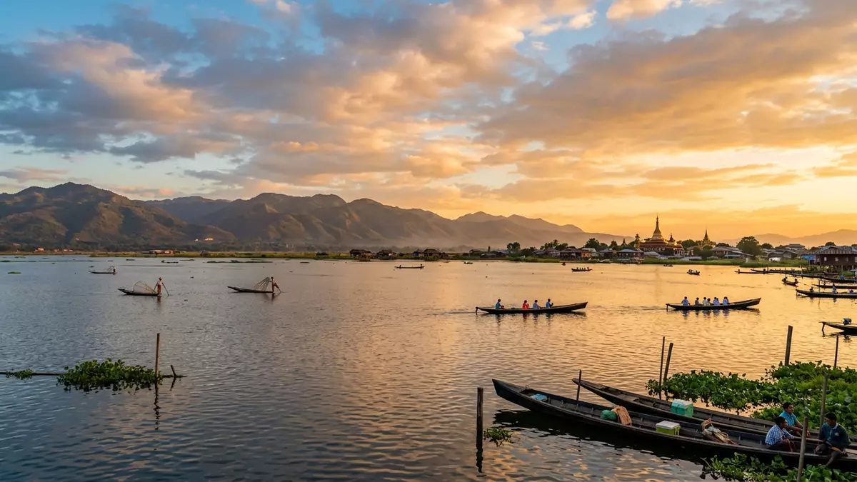
Inle Lake in Myanmar’s Shan State is a highland freshwater lake south of Nyaungshwe, known for communities who have built homes, fields and waterways directly on its surface.
A highland lake framed by the Shan Hills
Inle Lake lies within Nyaungshwe Township in the Shan Hills of eastern Myanmar, forming a long basin surrounded by low mountain ridges and cultivated valleys.Nyaungshwe Township in Shan State The lake sits at an elevation of over 900 m (2,953 ft), which gives the water and its shore settlements a noticeably highland character compared with many other Southeast Asian lowland lakes.over 900 metres above sea level It stretches roughly north–south, with a length of about 22 km (13.7 mi) and a width of around 11 km (6.8 mi), forming an elongated sheet of shallow water interlaced with reedbeds and channels.22 km long and 11 km wide
The broader basin is generally referred to as part of the Shan Plateau, and elevations around the lake reach around 3,000 ft (914 m).Shan Plateau at a height of 3,000 feet The lake’s surface area has been measured at figures around 116 km² and about 160 km² in different surveys, reflecting the difficulty of defining its extent where open water blends into marsh and floating vegetation.around 160 km² since the 1930s The combination of altitude, surrounding hills and changing boundary between water and vegetation gives Inle Lake a distinctive landscape character: long horizons across open water in some directions, and in others a patchwork of channels framed by reeds, houses on stilts and cultivated plots.
Intha leg?rowers and villages on the water
Inle Lake is especially associated with the Intha people, an ethnic group whose settlements line its shores and stand on wooden piles driven into the lakebed.home to the Intha people Houses rise above the water on timber supports, with walkways, boat landings and narrow channels forming the connective tissue between neighbourhoods. Many villages incorporate monasteries, small pagodas and simple communal structures that share the same stilted construction, giving whole clusters of buildings an appearance of floating above the lake. Canoes and long, narrow wooden boats serve as everyday transport, turning the waterways into thoroughfares for goods, school journeys and visits between families.
On the open stretches of Inle Lake, Intha boatmen have developed a distinctive leg?rowing technique that has become one of the lake’s most recognisable practices.one-legged rowing tradition Standing at the stern of their narrow boats, they wrap one leg around a single oar and use a twisting motion to drive the blade through the water, leaving their hands free to handle conical fishing nets or to steer through reedbeds.wrap one leg around a single oar This stance brings the rower’s eyes above the level of floating vegetation, an advantage in the shallow channels that connect villages with broader parts of the lake. The method is closely associated with Intha identity, and generations of fishers have used it while working for carp, catfish and other lake species.
Floating gardens and a cultivated lake surface
Beyond fishing, Inle Lake is known for extensive floating gardens that form productive agricultural plots directly on the water surface.floating gardens on the lake itself Farmers gather lake?bottom weeds and aquatic plants, haul them to chosen areas by boat, and stack them into elongated beds that are anchored in place with bamboo poles.floating beds anchored by bamboo poles Over time, these beds form thick mats of organic material that can support rows of crops. Tomatoes feature prominently, along with cucumbers, gourds and flowers, and the lake’s criss?crossing channels run between belts of cultivated vegetation that rise slightly above the surrounding water.
The extent of these floating gardens has increased since the mid?twentieth century, and they now occupy substantial areas along shorelines, especially on the western side of the lake.gardens cover large sections of the western shore Their presence is visible as bands of greenery threaded with narrow waterways where boats pass between plots. This practice turns parts of Inle Lake into a cultivated landscape where water, vegetation and human settlement are tightly interwoven: houses rise from the lakebed, crops grow on floating platforms and boat traffic moves along lanes that function both as transport routes and as boundaries between fields. Scientific studies of Inle Lake’s ecology have noted endemic fish and snail species within this environment, alongside concerns about sedimentation and water?quality pressure linked with expanding cultivation.endemic species of fish and snails
Shan highland climate and cultural context
Inle Lake occupies part of the Shan Highlands, an upland region east of Myanmar’s central plains, and the lake’s altitude gives it a climate distinct from hotter lowland cities.monsoonal climate description The lake receives significant monsoonal rainfall, with a wetter period in the middle of the year, and the surrounding hills show seasonal changes in vegetation and water levels in streams that feed the basin. Villages around Inle Lake belong administratively to Nyaungshwe Township, and nearby centres such as Taunggyi provide links to wider Shan State and to overland routes towards other parts of Myanmar.30 km south of Taunggyi
Ethnographic and geological studies have examined Inle Lake’s origins and long?term development, describing it as a tectonic lake formed in the Shan Plateau and linking human presence around its shores to ancient settlement patterns.tectonic lake formed around 1.5 million years ago The Intha communities have lived with the lake as a central organising feature, integrating Buddhist religious life with water?based livelihoods, and their leg?rowing and floating agriculture form part of this highland cultural landscape. From a traveller’s perspective, Inle Lake offers a combination of visible geography — a high?altitude basin framed by hills — and everyday waterborne practices that make the lake surface itself a lived, structured space.
Visiting Inle Lake: what travellers from Western Europe should know
- Inle Lake lies in Nyaungshwe Township in Shan State in eastern Myanmar, and travellers commonly reach the area via regional connections to Taunggyi and local road links to lakeside settlements.
- Much movement around Inle Lake takes place by boat along narrow channels, and in stilt villages walkways and simple bridges connect houses above the water.
- The lake’s highland setting means approaches from the surrounding hills involve modest altitude, and paths and roads in the basin include sections with gradients and uneven surfaces.
- The official language in the region is Burmese and the currency is the Myanmar kyat.
- Entry requirements depend on your nationality; UK travellers can check the FCDO travel advice at gov.uk/foreign-travel-advice, Irish travellers the Department of Foreign Affairs at ireland.ie.
Searching for Inle Lake on social platforms
These links open searches for Inle Lake on each platform.
Frequently asked questions about Inle Lake
Where is Inle Lake?
Inle Lake is in Nyaungshwe Township in Shan State in eastern Myanmar, within the Shan Hills, south of the regional centre of Taunggyi.
What can visitors expect on a visit to Inle Lake?
Visitors encounter a high?altitude freshwater lake with stilt villages, boat traffic, Intha leg?rowers and extensive floating gardens that occupy large sections of the water surface.
What makes Inle Lake distinctive among lakes in Myanmar?
Inle Lake is Myanmar’s second largest natural lake and one of its higher?altitude lakes, and it is closely associated with Intha communities whose livelihoods and settlements are built directly on the water.


