

Jokulsarlon, Iceland’s glacier lagoon of drifting ice
Published on 08/25/2026 at 13:01 | Editorial responsibility: Rafael Müller, Editor-in-Chief AD HOC NEWS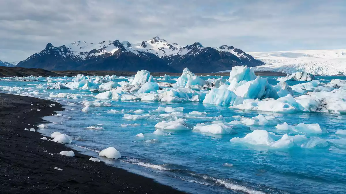
Jokulsarlon in south-east Iceland is a glacier lagoon where icebergs calve from the Breidamerkurjokull outlet of the Vatnajokull ice cap and drift across deep, cold water towards the Atlantic Ocean. Formed in the twentieth century as the glacier retreated, it lies beside Route 1 between Skaftafell and Hofn and has become a striking meeting point of ice, water and black volcanic sandin southern Vatnajokull National Park.
Icebergs, deep water and a changing lagoon
Jokulsarlon is a glacial lake fed directly by Breidamerkurjokull, an outlet glacier of Vatnajokull whose ice front has retreated inland over the past century, enlarging the basin of the lagoon as it does soto a depth of around 284 m (932 ft). As large blocks of ice break from the glacier, they drop into near-freezing water and become icebergs that move slowly across the surface, sometimes towering above visiting boats and lining up along the shore.
The lagoon covers about 25 km² (9.7 mi²), making it the largest glacial lake in Iceland by area and one of the country’s most striking inland bodies of waterwith the glacial front now about 8 km from the sea. Its waters appear still from a distance, yet currents below the surface carry ice towards the seaward outlet, where smaller pieces escape into the surf.
From lagoon to ocean and the black sands of Breidamerkursandur
On the seaward side of Jokulsarlon, meltwater from the lagoon flows through a narrow channel beneath Route 1 into the Atlantic, creating a short tidal estuary where floating ice swings back and forth with the movement of the seabefore washing onto the black sands of Breidamerkursandur. As the blocks of ice are worn down, they collect on the shore in slabs, shards and sculpted shapes, catching light against the dark lava-derived sand.
This stretch of coast, which includes the beach known as Diamond Beach, forms part of the wider Breidamerkursandur outwash plain, a landscape built over time by glacial rivers carrying sediment from Vatnajokull towards the seaon either side of Route 1. Standing on the sand, it is possible to look inland to the icebergs on the lagoon and seaward to the surf where smaller fragments disappear.
Jokulsarlon in Vatnajokull National Park and the south coast landscape
Jokulsarlon lies within Vatnajokull National Park, a protected area that takes in the ice cap itself, its outlet glaciers and parts of the surrounding lowlandsincluding Jokulsarlon and the neighbouring shore. The lagoon sits beside the Ring Road on Breidamerkursandur, between the Skaftafell area to the west and the fishing town of Hofn to the east, making it a natural stopping point on journeys along Iceland’s south coast.
The wider landscape around Jokulsarlon is shaped by the meeting of ice, volcanic rock and Atlantic weather systems. Vatnajokull’s outlet glaciers leave moraines and sandur plains behind as they advance and retreat, and Jokulsarlon’s deep basin is a direct result of this glacial movement carving into older depositsbefore filling with meltwater. Travellers passing through see not only the lagoon, but also distant ice tongues, roadside lava fields and the low-lying wetlands that mark the transition between mountains and sea.
Visiting Jokulsarlon: what travellers from Western Europe should know
- Jokulsarlon lies on Iceland’s Ring Road (Route 1) in south-east Iceland between Skaftafell and Hofn, and is reached by road transport that follows the main route across Breidamerkursandur.
- The ground at Jokulsarlon is uneven, with volcanic sand, gravel and low banks along the lagoon and beach; visitors move over natural terrain rather than paved urban surfaces.
- The nearest town is Hofn, east of the lagoon along Route 1, with other services and accommodation concentrated in Skaftafell and smaller settlements along the south coast.
- The official language is Icelandic and the currency is the Icelandic krona.
- Entry requirements depend on your nationality; UK travellers can check the FCDO travel advice at gov.uk/foreign-travel-advice, Irish travellers the Department of Foreign Affairs at ireland.ie.
Searching for Jokulsarlon on social platforms
These links open searches for Jokulsarlon on each platform.
Frequently asked questions about Jokulsarlon
Where is Jokulsarlon located?
Jokulsarlon is in south-east Iceland on Breidamerkursandur, beside Route 1 between Skaftafell and Hofn, within Vatnajokull National Park.
What can visitors expect when they reach the lagoon?
Visitors see a deep glacier-fed lake with large icebergs drifting across the water, a narrow outlet towards the Atlantic and a black sand beach scattered with ice fragments.
What makes Jokulsarlon distinctive compared with other Icelandic lakes?
Jokulsarlon is fed directly by Breidamerkurjokull, has substantial depth and an open connection to the sea, so icebergs can travel from an outlet glacier to the ocean within a single compact landscape.


