
Kenting Guojia Gongyuan, where Taiwan turns tropical
Published on 09/21/2026 at 11:29 | Editorial responsibility: Rafael Müller, Editor-in-Chief AD HOC NEWS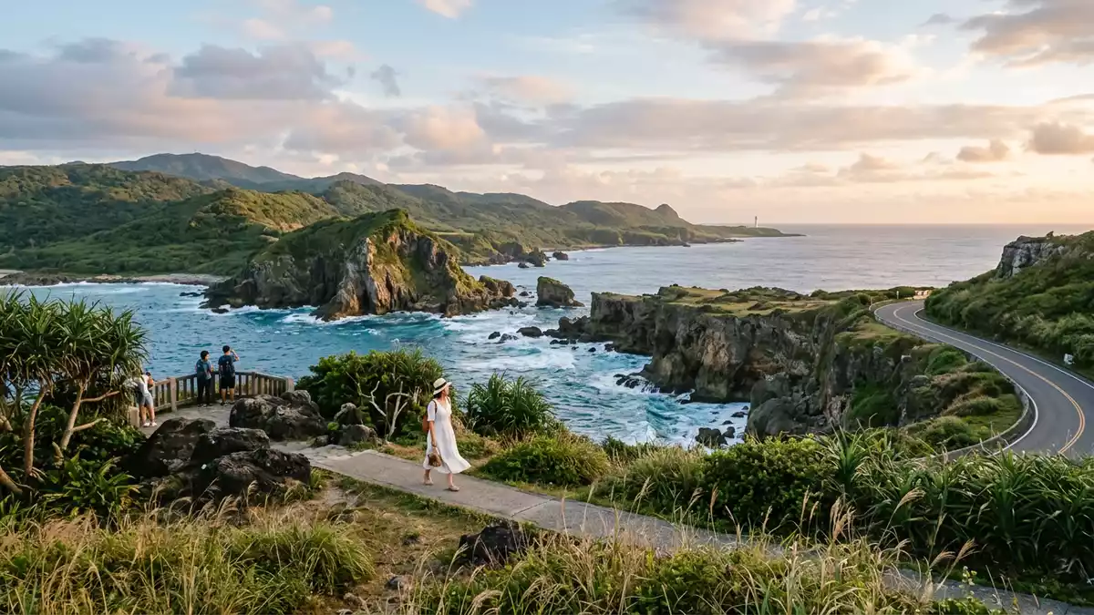
At the far southern tip of Taiwan, Kenting Guojia Gongyuan unfolds as a broad national park where coral-fringed shores, forested uplands and lived-in farmland share the same peninsula landscape. Established as Taiwan’s first post-war national park in the early 1980s, it protects both land and sea around the Hengchun Peninsula in Pingtung County and gives a clear sense of how tropical geology, coastal scenery and everyday rural life intersect here.Taiwan’s first national park
A tropical peninsula of land and sea
Kenting Guojia Gongyuan lies on the Hengchun Peninsula, the section of Pingtung County that forms the southernmost part of Taiwan’s main island, with the park’s districts extending across Hengchun, Checheng and Manzhou townships.Hengchun, Checheng and Manzhou The protected area combines an expanse of land in the low hills and coastal plains with a stretch of surrounding sea, giving the park a footprint that runs along both the Taiwan Strait and the Pacific side near the Bashi Channel.Land and nearshore sea
Across this peninsula, Kenting Guojia Gongyuan brings together several distinct terrains. Inland, the ground rises into limestone and uplifted coral reef plateaus, with patches of tropical forest and pasture. Towards the margins, the landscape opens out into agricultural fields, lakes such as Longluan Lake and low coastal dunes. Along the shore, there are sandy bays backed by vegetation, rocky promontories and reef-fringed platforms where waves meet exposed coral rock.Mountains, pasture, lakes, dunes and reefs
Coral geology and forested uplands
The geological character of Kenting Guojia Gongyuan is shaped by long uplift and coral growth, creating an extensive raised reef landscape. In parts of the park, these ancient reef formations form rough pavements and cliffs above the sea, while inland they underpin forested areas now known collectively as Kenting National Forest Recreation Area, where a dense tropical canopy has grown on former marine substrates.Uplifted coral reef forest The mix of limestone, coral rock and tropical vegetation gives the park’s uplands a distinctive texture compared with other parts of Taiwan.
Within this setting, Kenting Guojia Gongyuan supports a wide range of habitats. Coral reefs provide underwater structure for marine life along the coast, while forests and grasslands inland host tropical plant communities and serve as resting places for migratory birds crossing the region.Coral ecosystems and bird habitat The park’s lakes and wetlands add further variety, creating a mosaic of environments within a relatively compact corner of Pingtung.
Coastal landmarks and rural life
Along the ocean edge of Kenting Guojia Gongyuan, certain headlands and bays have become landmarks in their own right. Eluanbi Cape at the park’s southern tip carries a historic lighthouse, a structure long associated with sea routes around Taiwan’s southern point and now a recognised feature of the coastal landscape.Eluanbi Cape lighthouse Westward from here, bays such as South Bay lie between rocky points, while other areas of the shoreline show more exposed reef platforms and wind-shaped terrain.
Unlike national parks that centre entirely on wilderness, Kenting Guojia Gongyuan includes settled and cultivated land within its boundaries. Fields, small settlements and roadways sit alongside forest patches and protected coast, and agricultural areas remain part of the visible scene. This blend gives travellers a view of rural Taiwan within the same area as tropical forest, reef coast and headland scenery, making the park as much a lived landscape as a conservation area.Agricultural land within the park
Visiting Kenting Guojia Gongyuan: what travellers from Western Europe should know
- Kenting Guojia Gongyuan is reached at Taiwan’s southern end in Pingtung County, with road access running through Hengchun Township towards coastal areas and upland forest zones.
- The terrain varies from gentle coastal paths and sandy bays to rougher limestone and uplifted coral ground inland, where trails and roads may cross uneven rock and short slopes.
- The surrounding region includes lakes such as Longluan Lake and low hills rising behind the coast, so views from higher points can take in farmland, forest and wide sea horizons.
- The official language is Chinese and the currency is the New Taiwan dollar.
- Entry requirements depend on your nationality; UK travellers can check the FCDO travel advice at gov.uk/foreign-travel-advice, Irish travellers the Department of Foreign Affairs at ireland.ie.
Searching for Kenting Guojia Gongyuan on social platforms
These links open searches for Kenting Guojia Gongyuan on each platform.
Frequently asked questions about Kenting Guojia Gongyuan
Where is Kenting Guojia Gongyuan located within Taiwan?
Kenting Guojia Gongyuan is situated on the Hengchun Peninsula in Pingtung County, at the southern end of Taiwan’s main island, covering areas of Hengchun, Checheng and Manzhou.
What can travellers expect when visiting Kenting Guojia Gongyuan?
Travellers encounter tropical coastal scenery, raised coral and limestone terrain, patches of forest, lakes and agricultural land, all within one national park that combines land and sea.
What makes Kenting Guojia Gongyuan distinctive among Taiwan’s parks?
It is recognised as Taiwan’s first national park of the post-war era and the only tropical national park on the island, with uplifted coral geology, reef-lined coasts and a landscape that includes active farmland.


