
Kinderdijk’s windmills turn water management into a landscape
Published on 09/22/2026 at 20:08 | Editorial responsibility: Rafael Müller, Editor-in-Chief AD HOC NEWS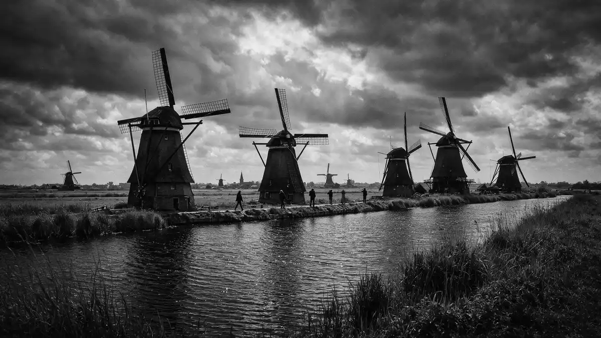
Kinderdijk is a landscape of canals, dikes and windmills in South Holland, where the machinery of water management remains visible across the Alblasserwaard polder. Nineteen windmills stand beside waterways near the meeting point of the Lek and Noord rivers, forming a long, open composition of timber, brick, grass and water.
Kinderdijk and the architecture of water
The windmills are not scattered ornaments. They belong to a connected hydraulic landscape, with channels, reservoirs, sluices, pumping stations and embankments arranged across low-lying land. The network carries the memory of a system that managed water for agriculture and settlement from the Middle Ages onwards.
The Mill Network at Kinderdijk-Elshout became a UNESCO World Heritage Site in 1997. Its significance lies in the relationship between the separate structures: the mills, waterways and hydraulic works read as one cultural landscape rather than as isolated monuments.
Kinderdijk’s setting is particularly legible from the paths beside the canals. Narrow strips of land divide watercourses, while the sails and roofs of the mills rise above reed beds and meadows. The view changes with the route, but the relationship between wind, water and timber remains constant.
Nineteen windmills, several traditions
The surviving mills belong to different groups and dates. Eight Nederwaard mills were built in 1738, while eight Overwaard mills date from 1740. Two mills serve Nieuw-Lekkerland, and the Blokweer mill represents an earlier type within the wider landscape.
The nineteen windmills and pumping stations show how water control developed through several forms of machinery. The mills lifted water between different levels, and pumping stations added mechanical power to the system.
Wisboom Pumping Station dates from 1868 and records the arrival of steam power at Kinderdijk. It was converted to electricity in 1924, linking the traditional mill landscape with the industrial history of Dutch water engineering. The building remains part of the site’s historical sequence.
The mills also preserve a working vocabulary of Dutch rural construction. Brick bases, wooden bodies, thatched roofs and turning sails vary from group to group. Their differences can be read from the paths, where each structure occupies a precise place beside a channel or embankment.
A living World Heritage landscape
Kinderdijk’s history reaches back beyond the surviving eighteenth-century mills. Floris V established water authorities in the Alblasserwaard in the thirteenth century, creating a collective framework for dikes, sluices and drainage.
The history of water management is visible in the landscape itself. Dikes mark the edges of reclaimed land, canals divide the polder, and sluices connect the managed waterways with the river system.
The name Kinderdijk means “children’s dyke” in Dutch. It is linked to a flood story involving a cradle and a cat, a local tradition associated with the Saint Elizabeth Flood of 1421. The story belongs to the cultural history of the place, while the mills and canals record its practical history.
Kinderdijk is also a village within the municipality of Molenlanden, in the province of South Holland. Its position beside the Lek and Noord gives the site a clear geographical identity: river, polder and engineered watercourse meet within one continuous view.
The UNESCO World Heritage landscape remains connected to water management rather than being a collection of decorative buildings. The windmills, pumping stations and channels belong to a system whose parts are understood together.
Visiting Kinderdijk: what travellers from Western Europe should know
- Kinderdijk lies east of Rotterdam in South Holland, at the meeting point of the Lek and Noord rivers. Regional buses and Waterbus services connect the site with Rotterdam and Dordrecht.
- The landscape is spread along canals and dikes, with much of the route outdoors. Paths follow narrow embankments beside watercourses and pass close to the mill groups.
- The WaterShuttle departs from Rotterdam’s Erasmus Bridge and travels directly towards Kinderdijk. Waterbus connections also operate from Rotterdam or Dordrecht.
- The official language is Dutch and the currency is the euro.
Searching for Kinderdijk on social platforms
These links open searches for Kinderdijk on each platform.
Frequently asked questions about Kinderdijk
Where is Kinderdijk?
Kinderdijk is in South Holland, east of Rotterdam, within the Alblasserwaard polder. The windmill landscape lies near the confluence of the Lek and Noord rivers.
What can visitors expect at Kinderdijk?
Visitors encounter canals, dikes, meadows, windmills and pumping stations along outdoor paths. Several buildings and machines explain the development of Dutch water management.
What makes Kinderdijk distinctive?
Kinderdijk brings nineteen historic windmills together with the hydraulic landscape they served. The UNESCO-listed site presents water management as a visible relationship between engineering, settlement and land.


