
Las Vegas Strip, the casino boulevard of the Nevada desert
Published on 09/19/2026 at 18:25 | Editorial responsibility: Rafael Müller, Editor-in-Chief AD HOC NEWS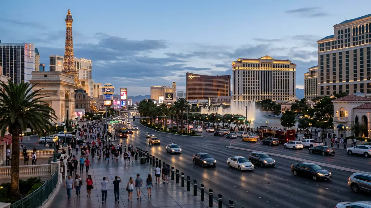
Las Vegas Strip is the name given to the dense, casino-lined section of Las Vegas Boulevard South where resort towers, themed facades and neon signs turn a desert highway into a continuous entertainment corridor. On this roughly four-mile (about 6.4 km) run through Clark County, Nevada, hotels, casinos and attractions stand shoulder to shoulder in an urban landscape that has grown out of the sand since the mid-twentieth century.
A desert highway turned resort corridor
The Strip occupies the southern part of Las Vegas Boulevard as it leaves the formal city limits near Sahara Avenue and runs through the unincorporated communities of Paradise and Winchester in the Las Vegas Valley.Las Vegas Boulevard This section of the road developed as a separate resort district from downtown Las Vegas along Fremont Street, which had earlier casinos and smaller properties.
The corridor that became the Strip grew along what had been Highway 91, a road also known as the Arrowhead Highway or Los Angeles Highway, linking Southern California with Nevada.the former Highway 91 alignment El Rancho Vegas, which opened along this highway in 1941, is widely cited in historical accounts as an early prototype of the modern Strip resort, showing how a single property began the transition from roadside stop to integrated hotel-casino complex.El Rancho Vegas in 1941
The four-mile spine of resorts and casinos
In many descriptions, Las Vegas Strip is defined as the stretch of Las Vegas Boulevard South between around Sahara Avenue in the north and Russell Road in the south, a distance of about 4.2 miles (6.8 km).4.2 miles from Sahara to Russell Within that reach of the boulevard, resort complexes line both sides of the road, forming what guide sites describe as north, centre and south sections of the Strip.north, central and south Strip
From Mandalay Bay at the southern anchor to the STRAT tower at the northern end, around thirty major resort casinos occupy plots along the Strip, creating one of the world’s densest concentrations of gambling and entertainment venues.around thirty resort casinos Among them, properties such as Bellagio, Caesars Palace, the Venetian, Wynn and MGM Grand have become reference points for the centre section, while resorts including Mandalay Bay and Luxor define the southern reaches and older properties like Circus Circus sit further north.major hotels along the Strip
Architecture, themes and landmarks along the boulevard
The Strip’s built environment is marked by large hotel towers rising above multi-level podiums that house casinos, theatres and shopping arcades, each resort presenting a distinct architectural theme to the boulevard. Luxor is known for a dark pyramid and associated structures evoking ancient Egypt, while New York-New York presents scaled interpretations of Manhattan landmarks around its casino floor.the pyramid and themed resorts The Venetian recreates canals and façades drawn from Venice, and Paris Las Vegas incorporates a tall replica of the Eiffel Tower as part of its frontage onto the street.
Alongside these resort themes stand free-standing landmarks that have become closely associated with the Strip. The Welcome to Fabulous Las Vegas sign, installed in 1959 near the southern end of the corridor, greets traffic approaching the main cluster of resorts and is one of the most recognised pieces of roadside design in Nevada.Welcome to Fabulous Las Vegas Sign At the northern end, the STRAT tower forms a slender vertical landmark visible across the valley, while fountains, observation wheels and other structures stand at various points along the boulevard, adding layers of spectacle to the continuous strip of hotels and casinos.the Strip from the Strat Tower to Mandalay Bay
Visiting Las Vegas Strip: what travellers from Western Europe should know
- Las Vegas Strip lies in Clark County in southern Nevada, running along Las Vegas Boulevard South between major intersections such as Sahara Avenue and Russell Road in the Las Vegas Valley.
- The boulevard passes through the communities of Paradise and Winchester, and the resort section consists of large hotel towers, multi-level casino podiums and wide pavements bordered by escalators, stairs and pedestrian bridges.
- McCarran’s successor airport, Harry Reid International Airport, sits to the east of the southern Strip, with the Mandalay Bay and Luxor resort cluster near the airport side of Las Vegas Boulevard.
- The official language is English and the currency is the United States dollar.
- Entry requirements depend on your nationality; UK travellers can check the FCDO travel advice at gov.uk/foreign-travel-advice, Irish travellers the Department of Foreign Affairs at ireland.ie.
Searching for Las Vegas Strip on social platforms
These links open searches for Las Vegas Strip on each platform.Frequently asked questions about Las Vegas Strip
Where is Las Vegas Strip located?
Las Vegas Strip is the informal name for the resort-lined part of Las Vegas Boulevard South in Clark County, Nevada, running through Paradise and Winchester in the Las Vegas Valley.
What can visitors expect on a first walk along the Strip?
A first walk brings continuous sightlines of large hotel towers, themed resort façades, casino entrances, pedestrian bridges and roadside landmarks along a straight urban boulevard.
What makes Las Vegas Strip distinctive among casino districts?
Its defining feature is the concentration of major hotel-casino resorts in a single corridor, from Mandalay Bay to the STRAT tower, forming a continuous entertainment district along one road.


