
Las Vegas Strip turns a desert highway into themed architecture
Published on 09/23/2026 at 18:35 | Editorial responsibility: Rafael Müller, Editor-in-Chief AD HOC NEWS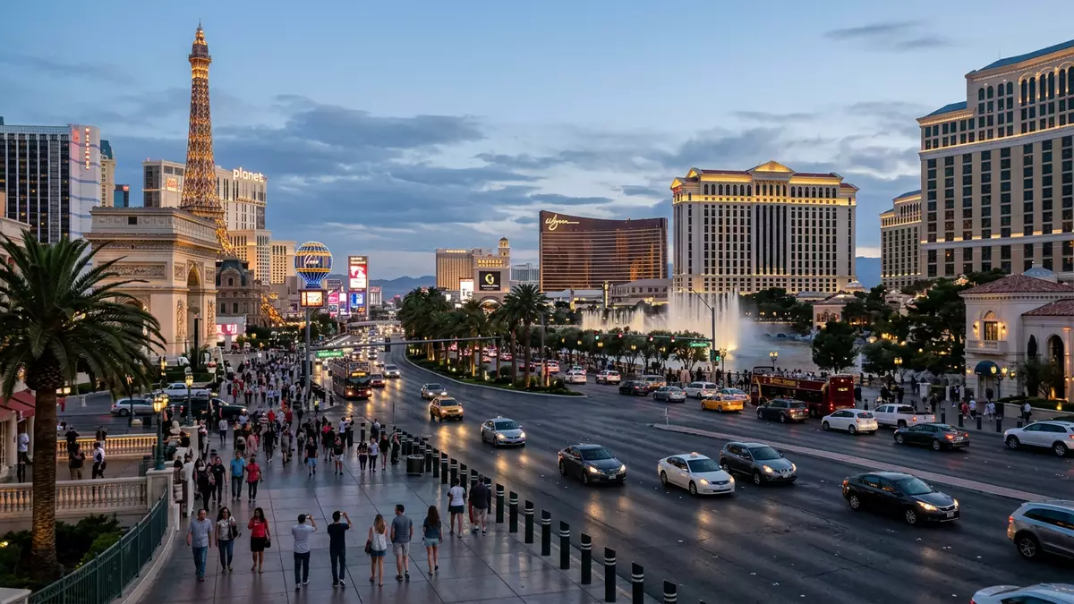
Las Vegas Strip is a long resort corridor on Las Vegas Boulevard South, south of the formal city of Las Vegas. Its casino hotels line a desert highway with towers, themed facades, signs, bridges and entertainment spaces, turning the road itself into an architectural display.
The corridor began with low roadside resorts and developed into a dense sequence of large themed properties. Its visible history runs from the western-style El Rancho Vegas in 1941 to the high-rise Riviera, the classical Caesars Palace and the mega-resort era opened by the Mirage in 1989.
Las Vegas Strip begins with El Rancho Vegas
The first major resort on the corridor was El Rancho Vegas, which opened beside Highway 91 in 1941. It introduced a western-style hotel-casino to the road that became Las Vegas Boulevard South. The city’s historical timeline records El Rancho Vegas as the first themed resort on what would become the Strip, followed by Last Frontier in 1942 and Flamingo in 1946. El Rancho Vegas in 1941 marks the beginning of the resort corridor’s recognisable identity.
Guy McAfee, a former Los Angeles police captain and gambler, is credited with naming the Strip in the 1940s. The name referred to Los Angeles’s Sunset Strip, while the Las Vegas corridor developed beyond the city boundary in Clark County. The road was previously known as the Los Angeles Highway and Highway 91.
From motel layouts to high-rise resorts
The earliest casinos followed a motel arrangement. Low buildings extended back from the road, with open parking areas between the frontage and the resort buildings. Large signs became prominent features of this landscape, marking separate properties along a broad highway.
The 1955 Riviera changed the visible scale of the corridor. Its nine-storey tower represented a move away from low motel-style buildings and towards vertical hotels. The architecture of the Strip then expanded through several distinct forms, including multi-wing hotel towers, large casino interiors and buildings shaped around recognisable themes. the Riviera’s nine-storey tower belongs to this transition.
Caesars Palace brought a Roman theme to the resort boulevard in the 1960s. Excalibur presented a castle-like exterior, while Luxor used an Egyptian theme and a pyramid form. These buildings made the resorts themselves into large signs, visible from the road before their interiors came into view.
A boulevard of buildings as signs
The Strip’s architecture is arranged as a sequence of strong visual identities. A pyramid, a castle, a Roman palace, a replica of New York’s skyline and a Parisian tower appear within the same resort corridor. The contrast comes from the buildings themselves, not from a single architectural style.
The Mirage, opened in 1989, introduced the mega-resort era. Large hotel towers, gaming floors, theatres, restaurants and indoor attractions gathered within single properties. The scale of these complexes changed the relationship between Las Vegas Boulevard and the buildings beside it.
Buildings that once stood behind open lots came closer together as the corridor became denser. Parking moved into rear areas and multi-storey garages, while resort entrances, signs and attractions occupied the street frontage. Pedestrian bridges connect parts of the boulevard, and public buses operate along the route. the Strip’s early casino resorts show how the corridor developed from roadside properties into a continuous entertainment district.
Visiting Las Vegas Strip: what travellers from Western Europe should know
- Las Vegas Strip runs along Las Vegas Boulevard South in Clark County, mainly through Paradise and Winchester. It lies south of the formal city of Las Vegas.
- The corridor is reached by road, public bus and taxi from the Las Vegas Valley. Las Vegas Harry Reid International Airport lies east of the southern resort district.
- The boulevard is a multi-lane urban road with pedestrian bridges, escalators, casino entrances and large resort forecourts. Walking between properties involves crossings, stairs, ramps and long internal routes.
- The official language is English and the currency is the United States dollar.
- Las Vegas lies in the Mojave Desert, with mountain ranges visible around the Las Vegas Valley. The Strip’s resort buildings, signs and themed facades occupy a largely north–south corridor.
Searching for Las Vegas Strip on social platforms
These links open searches for Las Vegas Strip on each platform.
Frequently asked questions about Las Vegas Strip
Where is Las Vegas Strip?
Las Vegas Strip follows Las Vegas Boulevard South through Clark County, mainly in the unincorporated communities of Paradise and Winchester. It lies south of the formal city boundary of Las Vegas.
What can visitors expect on the boulevard?
Visitors encounter casino resorts, hotel towers, themed exteriors, theatres, restaurants, pedestrian bridges, signs and large public-facing attractions. The route combines a multi-lane road with extensive walking routes through and between resort properties.
What makes Las Vegas Strip distinctive?
Its buildings function as both hotels and large-scale signs. Western motifs, Roman architecture, castles, pyramids and city replicas stand beside one another along the same desert resort corridor.


