

Mauao, the ancestral lava dome above Tauranga Harbour
Published on 09/14/2026 at 18:37 | Editorial responsibility: Rafael Müller, Editor-in-Chief AD HOC NEWS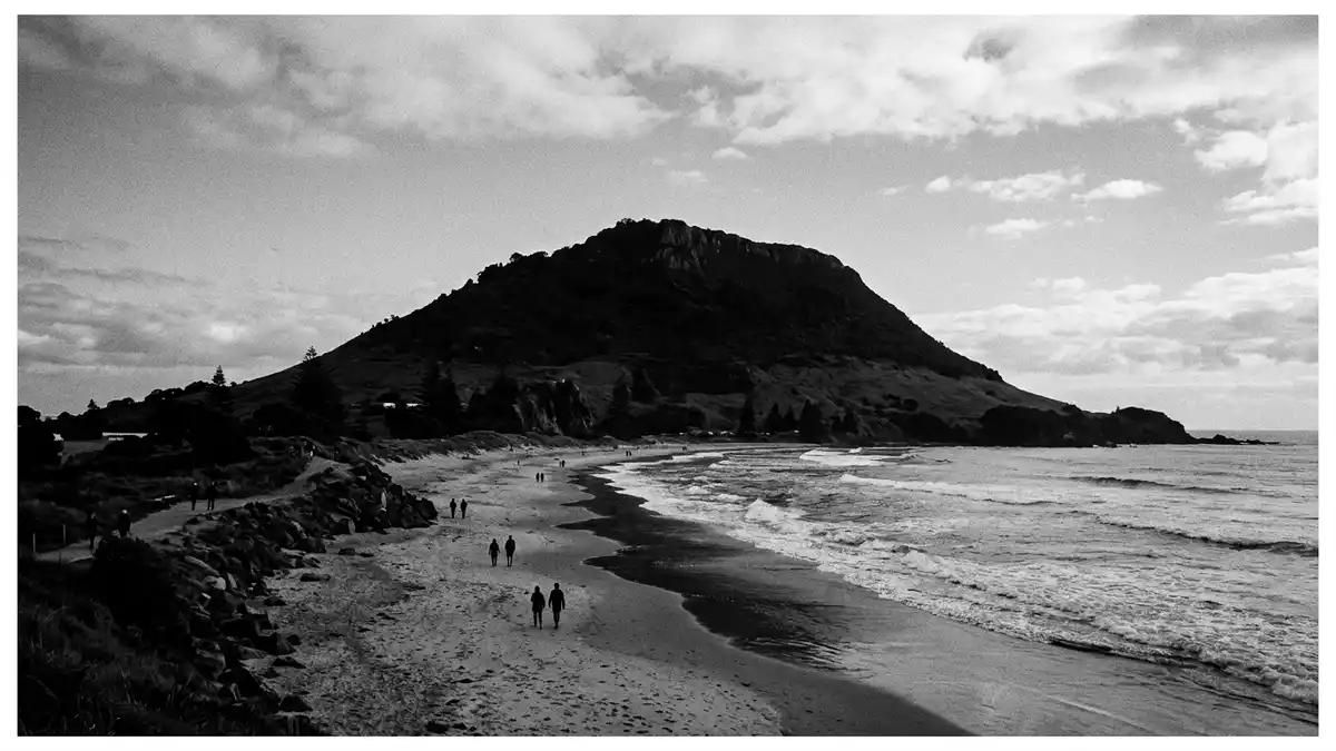
Mauao is a prominent lava dome at the entrance to Tauranga Harbour on the Bay of Plenty coast of New Zealand’s North Island, rising above the suburb that shares its name.The mountain reaches about 232 m (761 ft) and forms a compact headland where the harbour channel meets the open Pacific Ocean.
An ancestral mountain shaped by fire and legend
Mauao is described geologically as a rhyolite lava dome, the solidified remnant of volcanic activity on this part of the Bay of Plenty coast.Geologists identify Mauao as a rhyolite dome that has been shaped further by marine erosion around its base. The dome’s steep flanks drop towards sandy beaches on one side and the sheltered waters of Tauranga Harbour on the other, giving the mountain a clear outline against sea and sky.
The mountain carries deep cultural meaning as the sacred t?puna maunga, or ancestral mountain, of Tauranga Moana iwi including Ng?i Te Rangi, Ng?ti P?kenga, Ng?ti Ranginui and the iwi Waitaha.Its name Mauao is explained as “caught by the morning sun” in traditions that tell of a nameless hill pulled towards the ocean and fixed in place by dawn light. These narratives sit alongside the visible landscape that visitors encounter, linking the lava dome’s presence at the harbour entrance to stories that have been told for centuries.
Harbour headland between ocean surf and sheltered water
Mauao stands on a narrow peninsula that extends north-east from central Tauranga, where the harbour narrows towards its mouth and the open sea.The conical headland dominates the low coastal plain around it, rising from near sea level to its summit in a short horizontal distance. On the ocean side, broad sandy beaches face the Pacific swells; on the harbour side, tidal waters and moored vessels lie under the slopes, with the entrance channel running beside the base of the mountain.
The wider suburb spreads out from the foot of the dome along the peninsula, but Mauao itself is set apart as a reserve area with a distinct topography of steep grassy slopes, pockets of coastal forest and exposed rocky outcrops.The land at the mountain is held within the Mauao Historic Reserve and Mauao Recreation Reserve, reflecting its dual character as a cultural site and a place for outdoor activity. From the summit, on clear days, the view takes in the curve of the Bay of Plenty coast and the low inland hills beyond Tauranga.
Historic reserve, terraces and walking routes
The upper slopes and summit of Mauao carry traces of centuries of human occupation, including terraces and earthworks associated with former p?, or fortified settlements.Archaeological research identifies an archaeological landscape of around 600 years within the historic reserve, with terraces, defensive ditches and other features cut into the flanks of the dome. These remains sit among present-day grass and scrub, giving the slopes a layered appearance where natural contours and built forms overlap.
Over the years, tracks have been formed around the base of Mauao and up its sides, creating different walking routes that link the beaches and harbourfront with the summit area.Named routes such as the Oruahine and Waikorire tracks climb from the ocean side, while a track around the foot of the mountain traces the edge of the headland. Sections of these paths pass close to cliffs and steep slopes, and some segments use stairs or narrow benches cut into the hillside.
Visiting Mauao: what travellers from Western Europe should know
- Mauao rises on a peninsula north-east of central Tauranga in the Bay of Plenty region; the mountain stands beside the entrance channel to Tauranga Harbour and is reached over local roads.
- The terrain on Mauao changes quickly from level coastal paths to steep slopes, with tracks that use stairs and narrow sections and an ascent of over 200 m (around 650 ft).
- The coast around Mauao has extensive sandy beaches on the ocean side, while the harbour side offers calmer water and views of vessels moving through the entrance channel.
- The official language is English and the currency is the New Zealand dollar.
- Entry requirements depend on your nationality; UK travellers can check the FCDO travel advice at gov.uk/foreign-travel-advice, Irish travellers the Department of Foreign Affairs at ireland.ie.
Searching for Mauao on social platforms
These links open searches for Mauao on each platform.Frequently asked questions about Mauao
Where is Mauao located?
Mauao stands at the entrance to Tauranga Harbour on the Bay of Plenty coast of New Zealand’s North Island, forming the headland beside the harbour mouth.
What should visitors expect on a visit to Mauao?
Visitors encounter a steep lava dome with coastal tracks, stairs and summit routes, together with sandy beaches on the ocean side and views over Tauranga Harbour.
What makes Mauao distinctive among coastal mountains?
Mauao combines a compact volcanic dome, centuries of visible archaeological earthworks and its role as the ancestral mountain of Tauranga Moana iwi at a major harbour entrance.


