
Okavango Delta, an inland wetland world in northern Botswana
Published on 09/18/2026 at 22:07 | Editorial responsibility: Rafael Müller, Editor-in-Chief AD HOC NEWS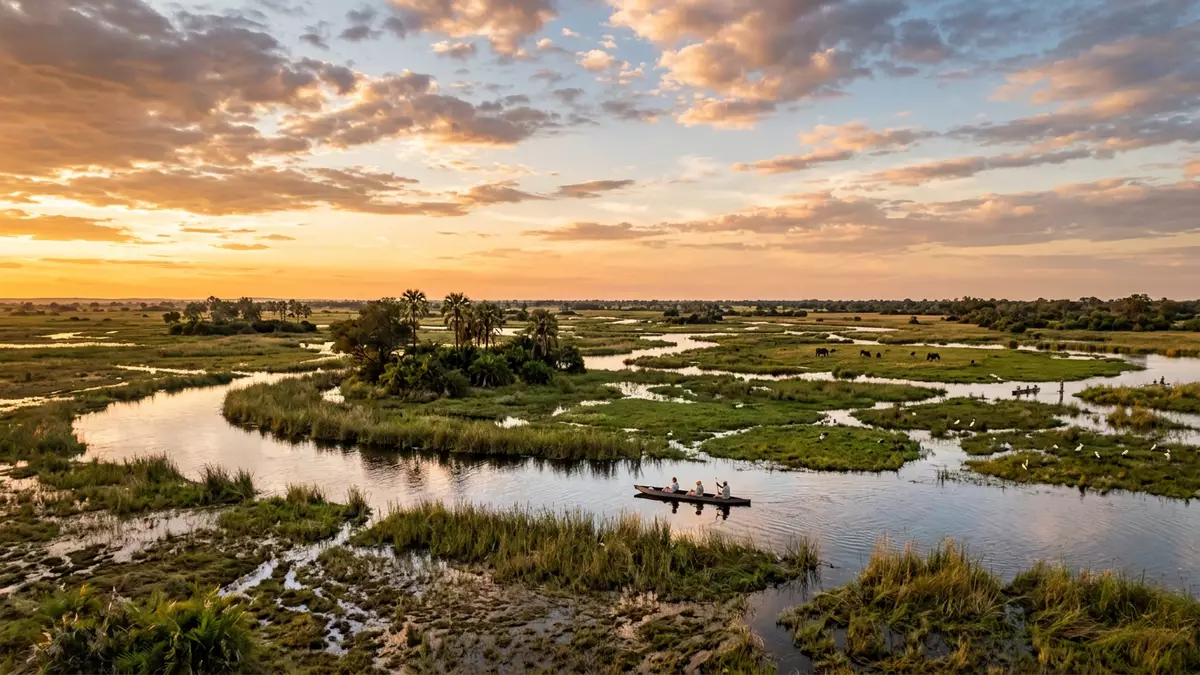
Okavango Delta near Maun in northern Botswana is a vast inland wetland where a river disappears into desert sands instead of reaching the sea. It is a protected landscape recognised as a UNESCO World Heritage Site and a Ramsar Wetland of International Importance, and its scale and seasonal flood patterns define almost everything a visitor sees.
An inland delta on Kalahari sands
Okavango Delta lies in the Ngamiland region of north-western Botswana, where the Okavango River arrives from Angola and spreads out over the Kalahari Basin in a broad alluvial fan. The river reaches a tectonic trough at an elevation of roughly 930 to 1,000 m (3,050 to 3,280 ft), forming one of Africa’s largest inland delta systems that drains into desert rather than the ocean.inland delta in Botswana The water disperses through a mesh of channels, lagoons, marshes and low islands, creating permanent swamps alongside seasonally flooded grasslands.
The World Heritage property covers more than 2,000,000 ha of wetland and floodplain, with a buffer zone that extends the protected landscape even further.inscribed World Heritage area In geographical terms, it is Africa’s third-largest alluvial fan and the continent’s largest endorheic delta, meaning its waters have no outlet to the sea and instead vanish into the sands of the Kalahari Basin.largest endorheic delta Fly over the Okavango in the flood season and the fan-like form is clear: darker permanent swamps in the centre, lighter seasonal fringes grading into dry savannah.
Flood pulse and wildlife in a protected wetland
The defining rhythm of Okavango Delta is the flood pulse of the Okavango River. Rain falling on the highlands of Angola takes several months to travel downstream, and the main flood reaches Botswana during the country’s dry season, raising water levels across the delta while surrounding plains remain parched.annual flooding in the dry season The result is a mosaic that changes through the year: some channels brim with clear water, others contract to pools, and floodplains alternate between submerged pasture and dry ground.
Plants and animals in Okavango Delta track this timing closely. The wetland supports reeds, grasses and woodland on slightly raised ground, and the shifting water line shapes where fish, antelope and predators move. It is recognised internationally for its biodiversity, including species such as cheetah, both white and black rhinoceros, African wild dog and lion that are noted among the large mammals of global conservation concern.endangered large mammals Protection under the Ramsar Convention and as a World Heritage Site reflects this ecological richness as much as the spectacle of water spilling into sand.Ramsar and World Heritage status
Okavango Delta and Maun as a point of access
For travellers from Western Europe, Maun is the practical gateway town to Okavango Delta. It lies at the south-eastern edge of the wetland system, on the Okavango River near the outlet where the floodwaters thin out into the broader Kalahari region.outlet of the Okavango at Maun From here, light aircraft, road transfers and river journeys fan north and west towards permanent swamps, private concessions and community lands inside and around the World Heritage property.
Within the delta itself, travel generally follows water and firm ground. Motorboats and traditional dugout canoes move along channels and across shallow lagoons, passing papyrus stands and grassy islands. Raised tracks and causeways run between dry-season settlements and wet-season grazing, and small airstrips on islands link remote areas with Maun and other towns. The combination of open water, saturated floodplains and patches of woodland makes Okavango Delta a landscape that alternates between reflection-filled lagoons and intricate vegetation, with wildlife, human activity and conservation administration all shaped by the flood pulse recognised in the UNESCO inscription.World Heritage Committee decision
Visiting Okavango Delta: what travellers from Western Europe should know
- Okavango Delta lies in north-western Botswana, with Maun at its south-eastern margin; access routes use Maun’s transport links and then continue into the wetland by air or along the Okavango River.
- The terrain combines open water, saturated floodplains and patches of dry ground, so visiting commonly involves boat travel and walking on uneven surfaces that may be sandy or muddy.
- Okavango Delta sits within the broader Kalahari Basin, and temperatures can be high in the dry season while nights may feel cool on exposed floodplains.
- The official language is English and the currency is the Botswana pula.
- Entry requirements depend on your nationality; UK travellers can check the FCDO travel advice at gov.uk/foreign-travel-advice, Irish travellers the Department of Foreign Affairs at ireland.ie.
Searching for Okavango Delta on social platforms
These links open searches for Okavango Delta on each platform.Frequently asked questions about Okavango Delta
Where is Okavango Delta in relation to Maun?
Okavango Delta lies in north-western Botswana, and Maun sits at its south-eastern fringe on the Okavango River near the outlet of the wetland system.
What kind of landscape should visitors expect?
Visitors encounter a broad inland delta with permanent swamps, seasonally flooded grasslands, channels, lagoons and low islands formed where river water spreads across the Kalahari sands.
What makes Okavango Delta distinctive among wetland areas?
It is a large endorheic inland delta where floodwaters arrive during the dry season, supporting diverse wildlife and earning both World Heritage and Ramsar protection as a major wetland system.


