
Pitons above Soufriere’s Caribbean coast
Published on 09/17/2026 at 18:19 | Editorial responsibility: Rafael Müller, Editor-in-Chief AD HOC NEWS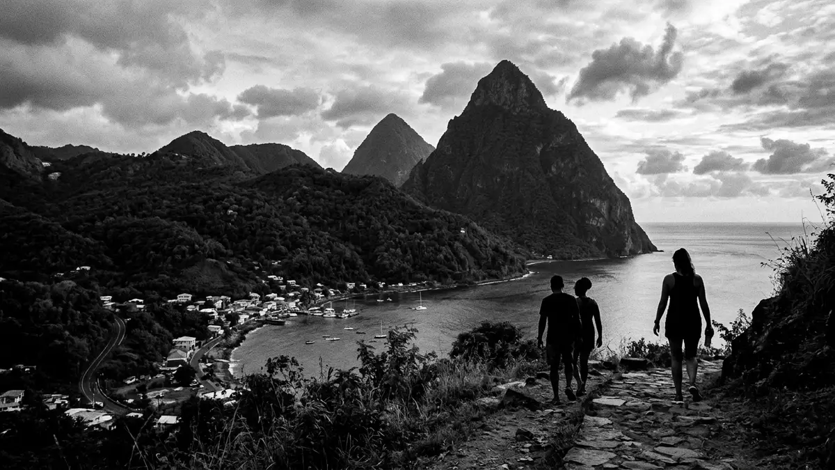
On the south?west coast of St Lucia, the Pitons rise steeply above the Caribbean Sea near Soufriere, forming twin volcanic spires that define the island’s most recognisable skyline. Their forested slopes and sharp profiles give the landscape a dramatic vertical focus, with Gros Piton and Petit Piton standing as the centrepiece of the wider Pitons Management Area, a protected zone of land and sea recognised on the UNESCO World Heritage List since 2004.
Volcanic peaks shaped over millions of years
The Pitons are remnants of an ancient volcanic system known as the Soufriere Volcanic Centre, where repeated eruptions and collapse left a complex of steep-sided peaks, ridges and depressions. Within this system, Gros Piton and Petit Piton form two lava domes or volcanic plugs, rising side by side above a caldera?like hollow sometimes described as the Qualibou Depression, which reflects the scale of the earlier stratovolcano that once occupied the site.Soufriere Volcanic Centre Their slopes are mostly clad in tropical vegetation, with the natural forest broken only by occasional clearings, and their bases merge into lower hills and valleys that carry trails, small settlements and access roads.
Measurements published for the Pitons differ slightly between sources, but they consistently present Gros Piton as the higher summit and Petit Piton as the lower, steeper cone, with both reaching well over 700 m (around 2,300 ft) above sea level.heights of Gros Piton and Petit Piton The two peaks are linked by Piton Mitan, a ridge that runs between them and forms part of the landward boundary of the Pitons Management Area, while the seaward side drops towards reefs and deeper water in the Caribbean.
A World Heritage landscape of land and sea
The Pitons Management Area covers a mix of terrestrial and marine zones near Soufriere, with its boundary drawn to include both peaks, the connecting ridge, the nearby Sulphur Springs geothermal field and a section of coastal waters and reefs. The total area is documented at 2,909 ha, combining around 1,134 ha of land and 875 ha of sea, and it was inscribed on the UNESCO World Heritage List on 30 June 2004 as a natural site recognised for both its volcanic geology and its exceptional scenic qualities.Pitons Management Area inscription Within this zone, forested slopes, hot springs, fumaroles, cliffs and marine habitats are treated as part of a single protected landscape.
The twin peaks themselves stand close to the shoreline, with Petit Piton towards the middle of Soufriere Bay and Gros Piton slightly further south between Soufriere and the coastal community of Choiseul.southwest coast near Soufriere This arrangement means that views of the Pitons often combine steep volcanic rock, tropical forest and the calm surface of the Caribbean Sea in a single frame, whether seen from boats offshore or from vantage points along the main road that approaches Soufriere from Castries.
Experiencing the Pitons from trails and viewpoints
For visitors based in Soufriere or on the surrounding coast, the Pitons are encountered in several ways: as distant silhouettes seen from beaches and bays, as close?up walls of vegetation when travelling at their base, and, for those who take to the paths, as long ascents on narrow routes through forest. Gros Piton has a more established route to its upper slopes, beginning near coastal communities south of Soufriere and climbing away from the shore on paths that gain height steadily before reaching viewpoints over the sea and neighbouring hills.Gros Piton hiking route Petit Piton, although lower, is markedly steeper and has routes where sections involve scrambling, making its paths suited to experienced climbers familiar with exposed terrain.
Even for those who stay at lower elevations, the Pitons influence the character of time in Soufriere. Roads and footpaths thread between foothills and ridges, with occasional clearings offering framed views of one or both peaks, and the presence of the Sulphur Springs area inland adds geothermal features such as hot pools and fumaroles to the mix of sights within reach.Sulphur Springs and volcanic features Along the coast, sections of reef and protected marine zones fall within the same management area, linking experiences on land with those on water under a single conservation framework.
Visiting Pitons: what travellers from Western Europe should know
- The Pitons rise near Soufriere on the south?west coast of St Lucia, with access to the surrounding area by road from Castries and by coastal routes serving Soufriere and Choiseul.
- The terrain around Gros Piton and Petit Piton includes steep paths on forested slopes, sections of narrow trails, and sustained gradients that require steady footing on uneven ground.
- The wider Pitons Management Area spans both hillsides and coastal waters, so viewpoints may involve short walks uphill from the road as well as boat journeys within Soufriere Bay.
- English is the official language of St Lucia and the currency is the Eastern Caribbean dollar.
- Entry requirements depend on your nationality; UK travellers can check the FCDO travel advice at gov.uk/foreign-travel-advice, Irish travellers the Department of Foreign Affairs at ireland.ie.
Searching for Pitons on social platforms
These links open searches for Pitons on each platform.
Frequently asked questions about Pitons
Where are the Pitons located on St Lucia?
The Pitons stand on the south?west coast of St Lucia near Soufriere, between that town and Choiseul, with their bases reaching towards the Caribbean Sea.
What can visitors expect when approaching the Pitons?
Visitors encounter steep, forested slopes, narrow paths and strong elevation gain, along with coastal views across Soufriere Bay and inland sights such as the Sulphur Springs geothermal area.
What makes the Pitons distinctive compared with other Caribbean landscapes?
The Pitons combine twin volcanic cones rising sharply from sea level, a surrounding World Heritage Management Area and a setting where protected land and marine zones meet within one compact region.


