
Ribeira, Porto’s layered riverfront of colour and stone
Published on 09/22/2026 at 13:05 | Editorial responsibility: Rafael Müller, Editor-in-Chief AD HOC NEWS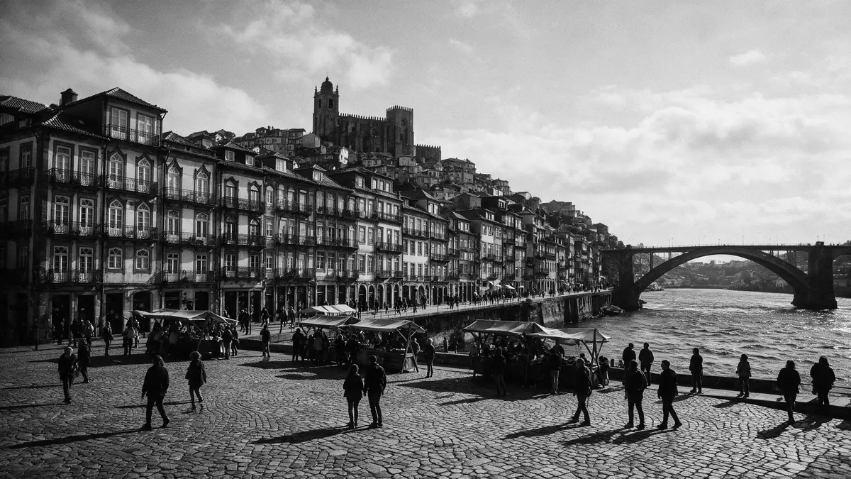
Ribeira is Porto’s riverside quarter, descending towards the Douro in a dense arrangement of lanes, steps, squares and tall façades. Its character comes from the visible layers of the city: medieval street patterns, later houses, a working quay and the iron span of Dom Luís I Bridge.
Ribeira descends from Porto to the Douro
The quarter occupies the northern bank of the Douro, below Porto’s higher historic districts. Streets run downhill towards Cais da Ribeira, while narrow passages and stairways connect the waterfront with the areas around Porto Cathedral and São Bento.
Praça da Ribeira forms the best-known open space beside the river. Its medieval origins are linked to Porto’s river port, and the surrounding buildings show the compact urban form associated with a long-established commercial district. Painted façades stand beside exposed masonry, balconies and arcaded ground floors.
The riverfront remains a place of movement and exchange. The Douro runs between Porto and Vila Nova de Gaia, where port-wine lodges occupy the opposite bank. Traditional rabelo boats are associated with the transport of wine barrels from the Douro Valley, linking the waterfront with the wider history of Portuguese commerce.
Medieval lanes, Baroque churches and iron bridges
Ribeira does not present a single architectural style. Its streets contain Romanesque, Gothic, Baroque and Neoclassical elements, with the built fabric rising in irregular layers above the quay.
São Francisco Church stands close to the riverfront and is known for its Gothic structure and richly decorated Baroque interior. The church belongs to the wider historic centre, where religious buildings, merchant houses and public structures form a continuous urban landscape.
At the eastern edge of Ribeira, Dom Luís I Bridge crosses the Douro to Vila Nova de Gaia. The double-deck metal arch was completed in 1886 and forms a powerful visual counterpart to the tightly packed buildings below. Its structure is part of the same historic setting as the quay and the opposite hillside.
The historic centre, including the bridge and the Monastery of Serra do Pilar, entered the UNESCO World Heritage List in 1996. The designation covers an urban landscape rather than a single monument, including streets, buildings, hillsides and the river setting. Historic Centre of Oporto is recognised for its long urban development and its relationship with the Douro.
Ribeira as a historic harbour neighbourhood
Ribeira’s identity grew around the river. The quay handled goods moving through Porto, and the Douro connected the city with inland vineyards and Atlantic trade. Commercial activity shaped the relationship between the water, the streets and the buildings above them.
The district’s urban form records that history without separating it into isolated monuments. A small square can open towards the river, while a lane beside it climbs sharply between houses. At street level, doors, balconies and shopfronts sit close together, leaving little space between private buildings and public routes.
Porto’s wider maritime history appears in nearby landmarks. The Stock Exchange represents a Neoclassical phase of the city, while Porto Cathedral retains a Romanesque core. The Church of Santa Clara adds a Portuguese Manueline reference to the historic centre.
The Douro provides the constant geographical reference. From the quay, the opposite bank rises towards Vila Nova de Gaia, and Dom Luís I Bridge links the two riverfronts within the protected historic landscape. Ribeira is therefore both a neighbourhood and a visible meeting point between city, river and bridge.
The place is best understood through its layers of colour, stone and metal. The riverfront promenade is broad enough to reveal the full arrangement, while the upper lanes show how closely the buildings are packed against the hillside. Ribeira Square’s history belongs to the long commercial life of Porto’s riverside.
Visiting Ribeira: what travellers from Western Europe should know
- Ribeira lies on Porto’s northern Douro bank. São Bento railway station, Rua das Flores and Dom Luís I Bridge provide named approaches from the upper city.
- The route from Porto’s higher districts descends through steep streets, steps and narrow lanes. Cais da Ribeira occupies the lower edge beside the water.
- Dom Luís I Bridge connects Ribeira with Vila Nova de Gaia. Its lower and upper decks offer distinct routes across the Douro.
- The official language is Portuguese and the currency is the euro.
Searching for Ribeira on social platforms
These links open searches for Ribeira on each platform.
Frequently asked questions about Ribeira
Where is Ribeira?
Ribeira is Porto’s historic riverside quarter on the northern bank of the Douro. It extends between the lower waterfront and the hillside streets leading towards Porto Cathedral.
What can visitors expect on a visit?
Visitors encounter a compact urban landscape of quays, squares, steps, narrow lanes, painted façades and historic churches. Dom Luís I Bridge provides a direct connection across the river to Vila Nova de Gaia.
What makes Ribeira distinctive?
Its identity comes from the close relationship between medieval streets, riverside commerce, colourful houses, the Douro and a nineteenth-century iron bridge. These elements form part of Porto’s UNESCO-listed historic centre.


