
Rottnest Island’s bays, dunes and quokkas off Perth
Published on 09/17/2026 at 20:12 | Editorial responsibility: Rafael Müller, Editor-in-Chief AD HOC NEWS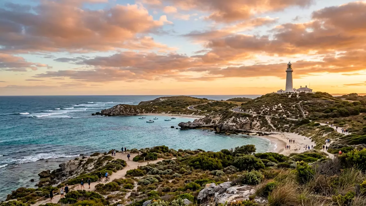
Rottnest Island off the coast of Perth in Australia is a low limestone island where clear bays, coastal dunes and the small wallaby?like quokka share a compact landscape shaped by wind and sea. A protected reserve with an Aboriginal name, Wadjemup, it lies in the Indian Ocean west of Fremantle and has become a distinctive escape from the mainland for people in Western Australia.
Low hills, salt lakes and surrounding Indian Ocean
Rottnest Island lies off the Western Australian coast in the Indian Ocean, west of Fremantle and Perth, and is separated from the mainland by a channel of open water that keeps its outline clearly visible on the horizon from the shore. The island is formed largely of coastal limestone, with shallow soils, sand dunes and several salt lakes occupying much of its interior, giving a mixture of pale rock, low vegetation and open water across a relatively small area.coastal limestone fragment The landmass stretches to about 11 km (6.8 mi) in length and up to 4.5 km (2.8 mi) in width, with a coastline that bends into numerous bays, coves and points.11 kilometres at its longest
Several named hills rise gently from this low profile. Wadjemup Hill is the highest point at around 45 m (148 ft) above sea level and carries the Wadjemup Lighthouse, a white landmark visible from many parts of the island and from vessels offshore.Wadjemup Hill Other elevations include Oliver Hill, Radar Hill and Mount Herschel, giving modest viewpoints over the salt lakes and the surrounding Indian Ocean. Between the hills and dunes lie shallow depressions where salt lakes have formed, including Lake Bagdad and Government House Lake, which reinforce the feeling that the interior is as much water and bare ground as vegetated land.
Bays, beaches and headlands around the shore
Rottnest Island’s coastline is articulated into a sequence of bays, coves and beaches, many with established names that appear on maps and local signs. On the northern side, Thomson Bay forms the main anchorage and front for the principal settlement, with jetties and low buildings facing the mainland and the Swan Coastal Plain across the water.Thomson Bay settlement Nearby lies The Basin, a small beach area backed by limestone and used as a sheltered swimming spot, while further north?west Geordie Bay and Longreach Bay curve around moorings and holiday accommodation.
West and south of the island, the shore becomes more exposed to the Indian Ocean, with bays such as Salmon Bay, Stark Bay and City of York Bay facing prevailing swells and wind?driven waves.named bays and coves Bathurst Point on the northern side carries the Bathurst Lighthouse, a smaller counterpart to the main Wadjemup tower, marking approaches to Thomson Bay and nearby reefs.Bathurst Lighthouse Around these headlands, offshore reefs and small islets break the waves into calmer inshore areas, creating a pattern of turquoise shallows over pale sand that contrasts with darker, deeper water beyond.
Quokkas, reserve status and layered human history
Rottnest Island is well known for the quokka, a small macropod related to wallabies that lives in groups among the scrub and settlement areas and has become closely associated with the island’s identity. Quokkas were once more widespread on the south?west mainland of Western Australia, but introduced predators led to declining numbers there, while the population on Rottnest Island in a protected setting has remained strong.quokka stronghold Rottnest has the status of a nature reserve, with conservation measures in place that limit certain activities and retain extensive native habitat for quokkas and other species.protected nature reserve
Human use of Rottnest Island has changed markedly across nearly two centuries. In the nineteenth century it was used as an Aboriginal penal settlement, later as a juvenile reformatory and, during the Second World War, as a military base with installations on elevated ground.Aboriginal penal settlement These past uses left structures and earthworks, some of which remain around Oliver Hill and other areas. Following those phases, the island developed as a resort serving people from the wider Perth area, with a small permanent population, accommodation and services arranged mainly around Thomson Bay.recreational and tourist destination
Visiting Rottnest Island: what travellers from Western Europe should know
- Rottnest Island lies off Western Australia in the Indian Ocean, west of Fremantle and Perth; services from the mainland use ferries and small aircraft to reach Thomson Bay and other landing points.
- The terrain combines low hills, sand dunes and salt lakes, with walking and cycling routes over exposed ground where shade can be limited and surfaces include compacted paths and soft sand.
- The official language is English and the currency is the Australian dollar.
- Rottnest Island sits near Perth on the Indian Ocean coast, so ocean conditions can influence access for vessels in stronger weather.
Searching for Rottnest Island on social platforms
These links open searches for Rottnest Island on each platform.
Frequently asked questions about Rottnest Island
Where is Rottnest Island in relation to Perth?
Rottnest Island lies off the coast of Western Australia in the Indian Ocean, west of Fremantle and the Perth metropolitan area, and is reached by sea and air links.
What can visitors expect on a day at Rottnest Island?
Visitors encounter low limestone hills, salt lakes and a coastline of named bays and beaches, with walking and cycling routes and frequent sightings of quokkas around vegetated areas and the settlement.
What makes Rottnest Island distinctive among nearby coastal areas?
The combination of a compact limestone island, protected reserve status, visible salt lakes, dual lighthouses and a strong quokka population gives Rottnest a character that differs from the urban mainland coast.


