
Stanley Park’s forested peninsula between city and sea
Published on 09/19/2026 at 17:31 | Editorial responsibility: Rafael Müller, Editor-in-Chief AD HOC NEWS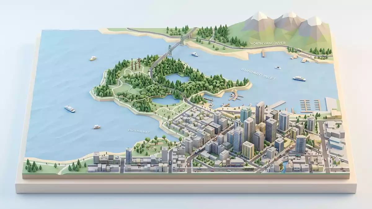
Stanley Park in Vancouver is a forested peninsula where an urban downtown meets tall coastal trees, wide water views and a looping waterfront path. The park occupies the north-western half of the city’s downtown peninsula and was officially opened as a public park in 1888, later named in honour of Governor General Lord Stanley of Preston.
A green peninsula shaped by water and forest
Stanley Park forms a broad tongue of land that projects into Burrard Inlet and English Bay, enclosed on three sides by seawater and on the fourth by the streets of central Vancouver and the West End neighbourhood. The park’s designation as a National Historic Site of Canada recognises this combination of forested and recreational land pressed against a dense urban core.forested and recreational land Much of its interior is covered by West Coast rainforest, with second-growth coniferous trees rising above winding roads and paths.
The overall area of Stanley Park is a little over 400 ha (990 acres), making it one of the largest urban parks within a Canadian city centre.a 405-hectare public park From within the park, the skyline of downtown appears across stretches of lawn, sports fields and ornamental gardens, while the North Shore mountains form a backdrop beyond Burrard Inlet. Water defines almost every long view, whether from the exposed western shore towards English Bay or from the northern edge towards the shipping channel under the Lions Gate Bridge.
The seawall circuit and viewpoints
For many visitors the defining feature of Stanley Park is the continuous seawall path that traces the outer edge of the peninsula, providing a full circuit beside the water. The route passes below the Lions Gate Bridge on the inlet side and curves round exposed points such as Prospect Point and Siwash Rock, where cliffs and rock formations rise directly above the path.wrapped almost entirely by the Seawall On calmer days the surface of Burrard Inlet reflects passing cargo ships and the bridge’s steel structure, while the western bays carry small boats and, further out, the open Pacific.
Prospect Point, near the northern tip of Stanley Park, is one of the classic viewpoints over the First Narrows and the Lions Gate Bridge, combining elevated views of the harbour with glimpses back towards downtown. Around the peninsula several beaches fringe the park’s edge, backed by lawns and trees and joined to the seawall by short side paths. Inland from the waterfront path, Lost Lagoon marks the shift from salt water to a managed freshwater environment within the park, its level surface often mirroring the trees and skyline around it.Lost Lagoon and the beaches
History, names and cultural landmarks
Stanley Park was officially declared a city park in 1888, following a decision by Vancouver’s council to secure the peninsula as a public reserve rather than allow intensive development. The park’s name honours Lord Stanley, who served as Governor General of Canada in the late nineteenth century, and whose title was attached to the park shortly after its opening.opened in 1888 and named in honour of Lord Stanley Long before its municipal designation, the area had been part of the traditional territories of local First Nations, whose histories remain present in parts of the landscape.
Among the most recognisable cultural landmarks inside Stanley Park are the totem poles near Brockton Point, where carved poles stand in a clearing with interpretive panels and views back towards the city and harbour.sites, landmarks and totem poles The park also contains the Vancouver Aquarium, established in the twentieth century and now housing extensive aquatic exhibits under modern roofs in one of the central clearings.home to the Vancouver Aquarium since 1956 Around these focal points lie gardens, pavilions and monuments, together forming a sequence of spaces between the denser forest stands.
Visiting Stanley Park: what travellers from Western Europe should know
- Stanley Park occupies the north-western part of downtown Vancouver’s peninsula, bordered by Burrard Inlet, English Bay and the West End, and is reached on foot, by bicycle, by bus or by road from the city centre.
- The terrain combines paved seawall paths with interior roads and forest trails, including gentle gradients, occasional steeper sections and some longer walking distances between viewpoints and facilities.
- Within the park, landmarks such as Prospect Point, Brockton Point and Lost Lagoon sit in different corners of the peninsula, so visits that take in several areas involve moving between waterfront edges and interior clearings.
- The official language is English and the currency is the Canadian dollar.
- Entry requirements depend on your nationality; UK travellers can check the FCDO travel advice at gov.uk/foreign-travel-advice, Irish travellers the Department of Foreign Affairs at ireland.ie.
Searching for Stanley Park on social platforms
These links open searches for Stanley Park on each platform.
Frequently asked questions about Stanley Park
Where is Stanley Park within Vancouver?
Stanley Park occupies the north-western half of Vancouver’s downtown peninsula, bordered by Burrard Inlet, English Bay and the central business district.
What should visitors expect on a first visit?
Visitors encounter extensive coastal forest, a continuous seawall path around the peninsula, viewpoints over the harbour and mountains, and cultural sites such as totem poles and the Vancouver Aquarium.
What makes Stanley Park distinctive among city parks?
The park’s combination of large-scale coastal rainforest, surrounding seawater, proximity to dense urban streets and its late nineteenth-century origins gives it a character that is closely tied to Vancouver’s geography and history.


