
Trolltunga, the cliff ledge above Ringedalsvatnet
Published on 09/17/2026 at 17:47 | Editorial responsibility: Rafael Müller, Editor-in-Chief AD HOC NEWS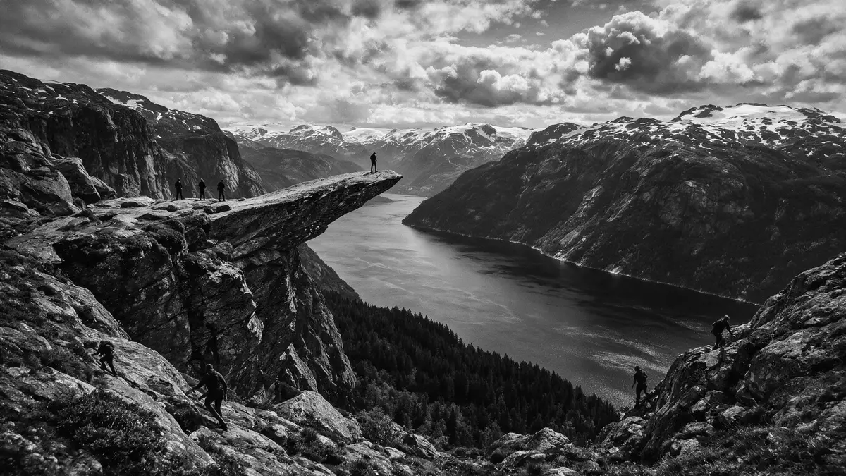
Trolltunga is a horizontal cliff ledge in the mountains of Ullensvang in western Norway, projecting far above the long, narrow lake Ringedalsvatnet. The rock formation lies in Vestland county in the Hardanger region and has become one of Norway’s best known high-mountain viewpoints for its exposed position over water and steep slopes.
A rock ledge on the Hardanger plateau
Trolltunga is a natural rock formation in Ullensvang municipality in Vestland, inland from the Hardangerfjord coastline in western Norway.Ullensvang municipality in Vestland The ledge sits high in the mountains above Ringedalsvatnet, a glacial lake that stretches below as a long corridor of water framed by steep valley sides.high above Ringedalsvatnet From the lake surface the cliff face rises in a single sweep of ancient bedrock, with the ledge projecting from it as a distinct shelf.
The elevation of Trolltunga is documented at 1,126 m (3,694 ft) above sea level, giving the ledge the character of a high-mountain balcony.1,126 m above sea level The drop from the rock down to Ringedalsvatnet below is around 700 m (2,300 ft), meaning that a person standing on the ledge has a clear vertical gap between themselves and the water.about 700 m above the lake The name, which translates as “Troll’s Tongue” in Norwegian, refers to the way the rock extends from the cliff, resembling a tongue reaching over the valley.
Bedrock, plateau and lake
The mountains around Trolltunga form part of the inland Hardanger landscape, where hard Precambrian bedrock has been carved by glaciers into plateaus, steep slopes and deep lakes.hard Precambrian bedrock Ringedalsvatnet occupies one of these valleys, and Trolltunga sits near the edge of the plateau above it, so that the ledge overlooks both water and surrounding peaks. The contrast between the relatively level mountain surface and the sudden drop to the lake is central to the site’s character.
From the ledge the view takes in Ringedalsvatnet stretching along the valley, with steep slopes falling directly to the shoreline and higher ridges rising beyond.above Ringedalsvatnet in Ullensvang The rock itself forms a firm platform over this scene, jutting out from the cliff face in a distinctive horizontal shape. Around it, the plateau is punctuated by small lakes, patches of exposed rock and stretches of alpine vegetation, creating a high-altitude landscape that feels markedly different from the fjord shores lower down.
The long high-mountain approach from Skjeggedal
Trolltunga is reached on foot from the mountain valley of Skjeggedal above the town of Tyssedal, near the head of the Hardangerfjord in Ullensvang.from the mountain valley of Skjeggedal The main trailhead lies near Skjeggedal and climbs through varied mountain terrain before reaching the plateau above Ringedalsvatnet, where the route continues towards the ledge.main trailhead at P2 Skjeggedal
The standard hiking route is an out-and-back journey from Skjeggedal to Trolltunga and back along the same marked path, covering over 20 km (12.4 mi) in total with a significant amount of ascent and descent.demanding out-and-back day hike The trail climbs through forest and onto open high-mountain plateaus, crosses undulating ridges and passes small tarns and marshy sections. For much of the route, views open towards Ringedalsvatnet and surrounding mountains, and the final approach brings the walker close to the cliff edge before the ledge itself comes into view.
Visiting Trolltunga: what travellers from Western Europe should know
- Trolltunga lies in Ullensvang municipality in Vestland, in western Norway’s Hardanger region, inland from the Hardangerfjord and above the lake Ringedalsvatnet. The usual access is via the town of Tyssedal and the mountain valley of Skjeggedal.
- The hike begins from road access points in Skjeggedal and follows marked high-mountain paths across plateaus and ridges. The terrain includes steep initial climbs, long stretches on exposed bedrock and sections where the path runs close to the cliff edge near Ringedalsvatnet.
- The area is part of Norway, where the official language is Norwegian and the currency is the Norwegian krone.
- Trolltunga is a high-mountain site with a substantial altitude difference between trailheads and ledge. Weather on the plateau can change quickly, and the approach involves sustained walking on uneven rock and soil under alpine conditions.
Searching for Trolltunga on social platforms
These links open searches for Trolltunga on each platform.
Frequently asked questions about Trolltunga
Where is Trolltunga?
Trolltunga is in Ullensvang municipality in Vestland county in western Norway, in the Hardanger region, high in the mountains above the lake Ringedalsvatnet.
What should visitors expect on a visit?
Visitors reach Trolltunga on a demanding high-mountain hike from Skjeggedal, involving steep climbs, long distances on rugged terrain and an exposed ledge high above a lake.
What makes Trolltunga distinctive?
Trolltunga is distinctive for its horizontal rock ledge that juts out from a cliff around 700 m above Ringedalsvatnet, forming a natural platform with extensive views over water and mountains.


